Teacher guide
Where the Earth Leaks Heat
What can the surface of the land tell us about the energy beneath it, and what should we do with what we find?
Print this guide
At a glance
- Grades
- 9-10, 11-12
- Subjects
- Earth Science, Environmental Science, Physical Science
- Time
- 45 minutes core. 15-minute and 90-minute paths included.
- Preparation
- light
- Standards
- HS-ESS2-3, HS-ESS3-1, HS-ESS3-2; CCSS.ELA-LITERACY.RST.9-10.7, CCSS.ELA-LITERACY.WHST.9-12.1
- Materials
- Projector or student devices, Student handout, Pencil
Prior knowledge
Students should already know that the Earth has a layered interior that gets hotter with depth, that heat moves by conduction and convection, and that the boiling point of water depends on pressure as well as temperature. They do not need any prior exposure to geothermal energy.
If your class has not yet covered pressure and boiling point, spend three minutes on it before you begin, because the whole investigation turns on it.
Key vocabulary
- Geothermal gradient
- The rate at which temperature increases with depth. On average, roughly 25°C per kilometer.
- Hydrothermal
- Involving hot water. A hydrothermal system is one where groundwater is being heated by rock below.
- Sinter
- Silica dropped out of hot water as it cools. It builds the white and gray crust in the geyser basins.
- Travertine
- Calcium carbonate dropped out of hot water. It builds the terraces at Mammoth Hot Springs.
- Thermophile
- An organism that lives at temperatures most life cannot tolerate. The orange, brown and yellow colors in these photographs are mats of them.
- Permeability
- How easily fluid moves through rock. Hot rock with no permeability holds heat you cannot reach.
- Reservoir
- The body of hot water or steam underground that a geothermal plant would draw from.
Background for the teacher
Everywhere on Earth the ground gets hotter as you go down, on average about 25°C per kilometer. Under most of the country you would have to drill several kilometers to find water hot enough to boil. Under Yellowstone you do not have to drill at all.
Yellowstone sits above an enormous body of partly molten rock left over from volcanic activity that is still going on. Groundwater seeps down through fractures, gets heated far past the temperature at which it would normally boil, and stays liquid only because the weight of water above holds it under pressure. When it finds a path back up, the pressure drops and some of it flashes to steam. That is what the steam in these photographs is. Nothing is burning.
The water does not come back empty-handed. Hot water under pressure is an aggressive solvent. In the geyser basins it moves through rhyolite, dissolves silica, and drops it at the surface as the white and gray crust called sinter. At Mammoth, twenty miles north, the water moves through limestone instead, dissolves calcium carbonate, and builds the stepped travertine terraces in photograph 7. Same process, different rock, completely different landscape. That contrast is worth pointing at directly.
The color is the part students will not guess. The oranges, rusts, yellows and browns are not minerals and not rust. They are mats of thermophiles, microorganisms living in water far too hot for almost anything else. Different species tolerate different temperature bands, so they sort themselves along the cooling gradient. Water leaving a spring at near boiling supports one community; forty meters downhill, cooler, it supports another with a different pigment. The result is that in a geyser basin the color of the ground works as a rough thermometer.
None of this happens uniformly. A geothermal field is patchy. One vent can be scalding while ground fifty meters away is cool enough to walk on, because what controls the pattern is not heat alone but plumbing: the specific network of fractures that lets water move. Hot rock with no cracks in it is useless to a power company, because there is no way to circulate fluid and carry the heat out.
That is the crux. Surface features prove heat is escaping. They do not tell you reservoir temperature at depth, how deep it sits, how much water it holds, or how fast it recharges. Companies have drilled expensive wells into landscapes that looked extremely promising from above and found nothing worth producing.
Yellowstone is not a marginal prospect. The National Renewable Energy Laboratory notes that dry steam resources, the hottest and most directly usable kind, are known at only two locations in the United States: The Geysers in California, and Yellowstone. Only The Geysers operates commercially. Yellowstone does not, because it is not allowed to.
The Geothermal Steam Act of 1970 prohibits geothermal leasing inside national parks. The 1988 amendments went further and blocked leasing in the Island Park known geothermal resource area outside the park boundary, on the reasoning that drilling nearby could still damage the features inside it. Sixteen National Park Service units, Yellowstone among them, have designated “significant thermal features” that federal agencies must protect, and the Bureau of Land Management is barred from issuing leases where operations are likely to cause significant adverse effects.
So the country decided, deliberately and more than once, to leave one of its best geothermal resources in the ground. Students can evaluate that decision. It is a genuine cost-benefit judgment with real numbers on one side and things that are hard to price on the other, which is precisely what HS-ESS3-2 asks for.
Geothermal supplied about 16 billion kilowatt-hours in 2025, roughly 0.4 percent of United States utility-scale electricity, from plants in seven states. California accounts for about 69 percent of that and Nevada about 25 percent, with Utah, Hawaii, Oregon, Idaho and New Mexico making up the rest. It stays small because conventional plants need hot rock, water, and permeable ground all in the same place, and that combination is rare. Enhanced geothermal systems attack the problem by drilling into hot dry rock and engineering the permeability. As of 2026 that has moved out of the laboratory: commercial-scale wells demonstrated, drilling costs roughly halved, large power purchase agreements signed, with projects in Utah and Nevada leading. If it works at scale, the map of where geothermal is possible expands enormously, and the question of whether to develop protected places gets easier rather than harder.
The photographs
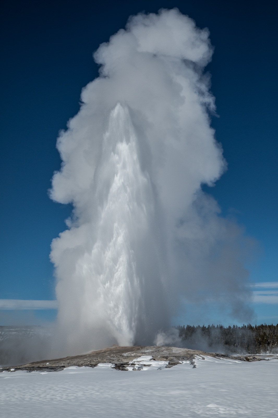
1. anchor An eruption is the loud part. The quiet part is the ground it stands on: snow lies across the whole basin and up to the treeline, but the low mound around the vent stays bare, because heat is reaching the surface there and nowhere else in the frame. The column is water and steam, thrown up and blown downwind. 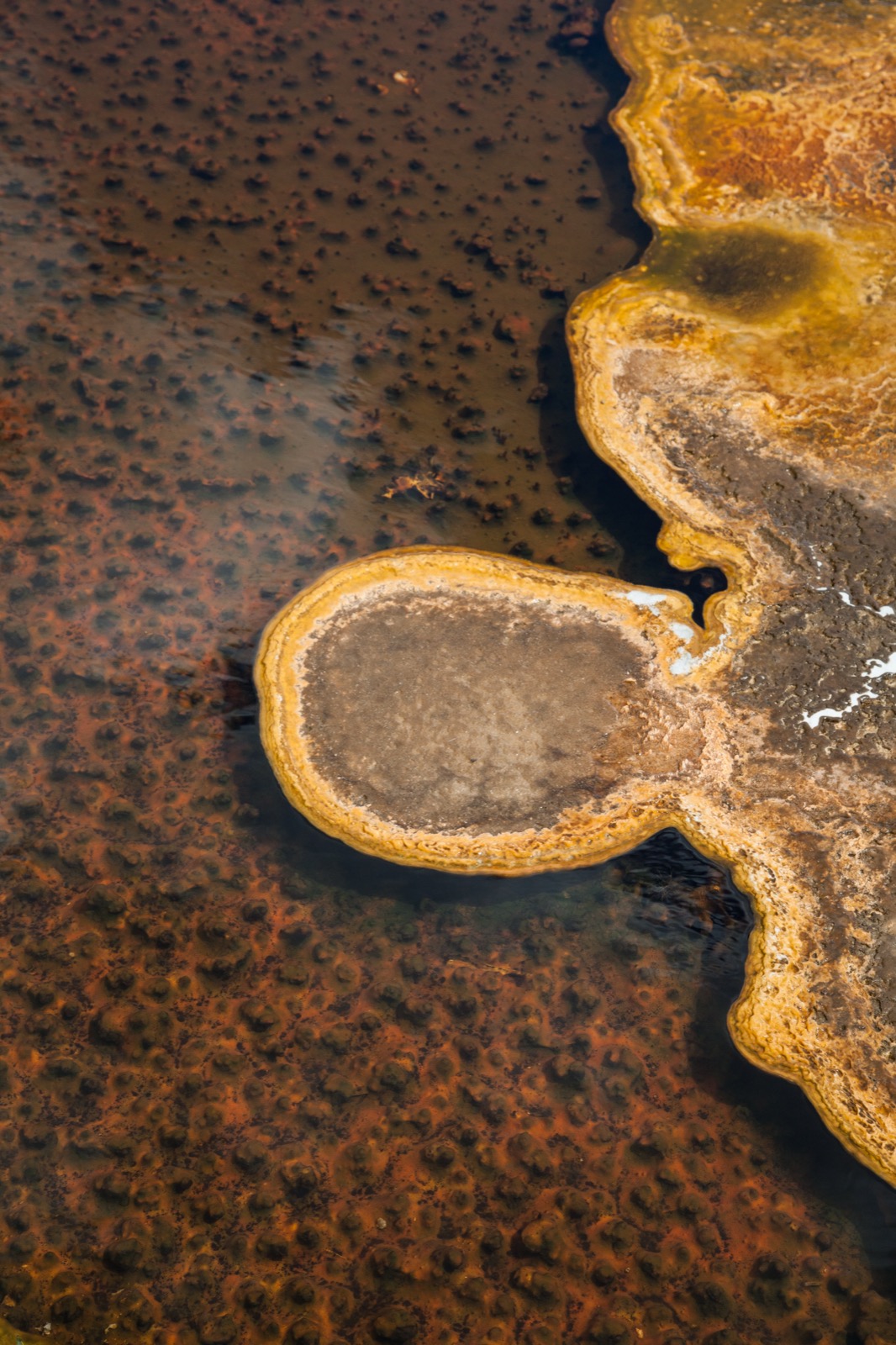
2. detail Two different processes, side by side in one frame. The rust-and-orange floor under the shallow water is mat — living, and lumpy at a scale you can see without a lens. The pale gold rim standing proud of the water is not alive: it is mineral, dropped out of solution at the edge where the water is shallowest and cools and evaporates fastest. The island near the middle is the same rim closed into a ring. 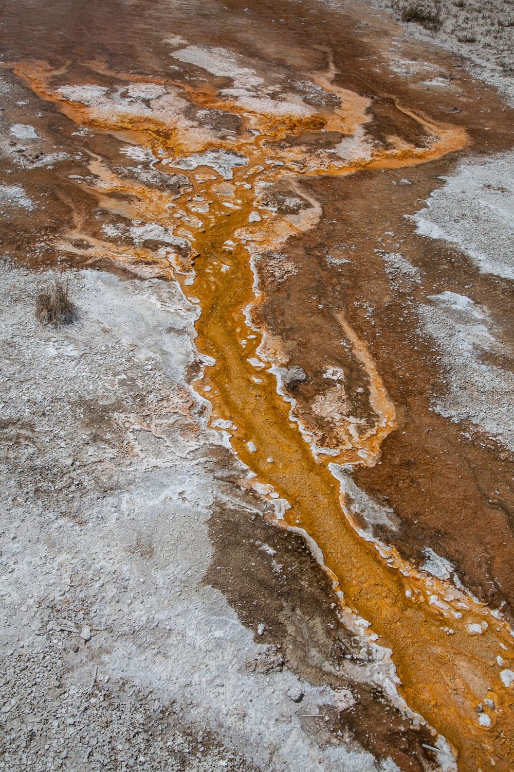
3. comparison Hot water leaves a spring and runs downhill across white sinter. The bright orange stripe down the middle is not mineral. It is alive: mats of heat-loving microbes that survive only in a narrow band of temperature. The water is hottest in the channel and cools as it spreads, so the color of the ground is a rough map of temperature. 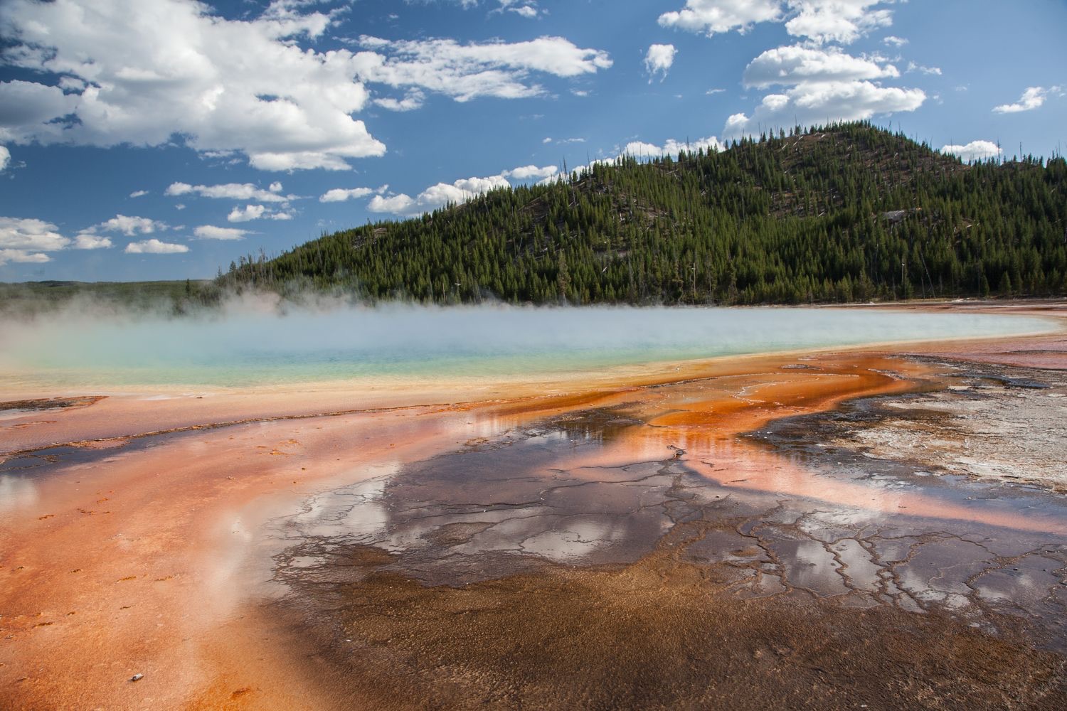
4. context Steam lifts off water hot enough to kill almost anything that falls in. The orange and brown bands in the foreground are microbial mats living in the cooler runoff. A lodgepole pine forest stands a few hundred meters away, entirely unbothered. 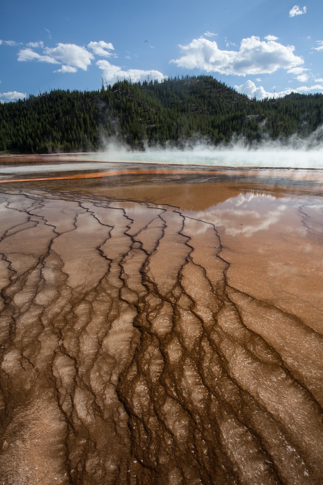
5. detail Close in on the runoff apron. The mat is not a smooth sheet. Water spreading downhill has cut a branching network of channels, and each channel carries slightly different temperature and chemistry, which is why the browns and oranges shift from ridge to groove. 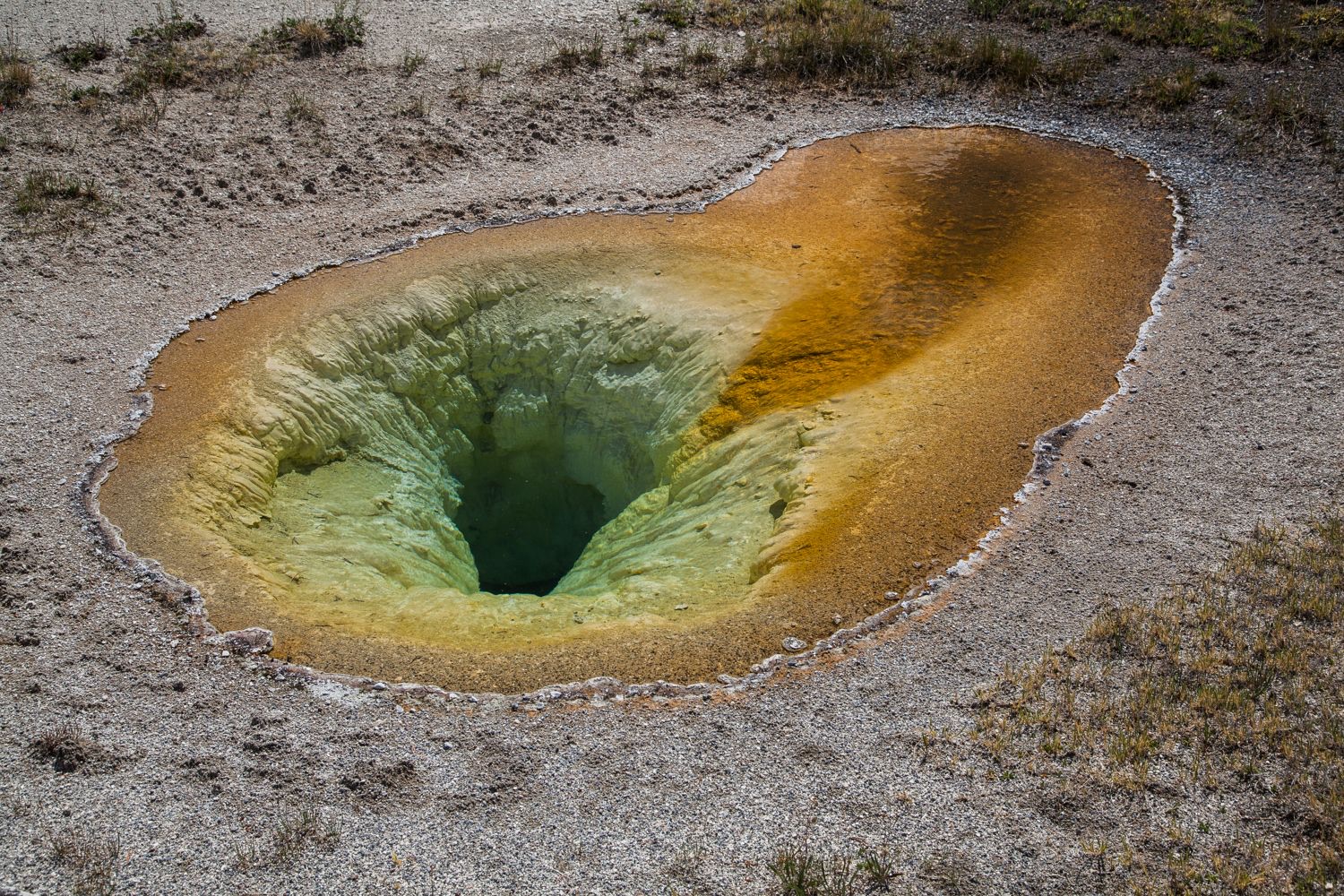
6. comparison A hot spring a short walk from the runoff channel. The throat drops away steeply and shifts from yellow-green to near black with depth. The rim carries the same orange mats, but here the water sits and cools slowly instead of running, and the result looks nothing like the channel. 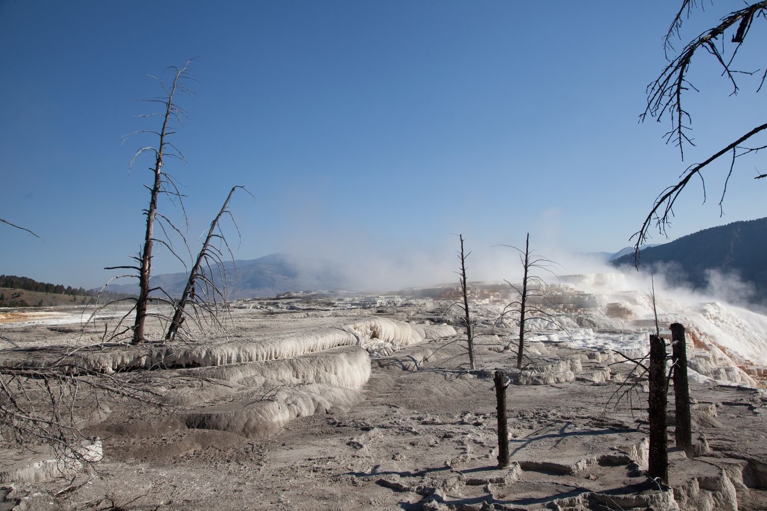
7. scale-and-change The white steps are travertine, calcium carbonate dropped out of the water as it cooled. The dead trees give you the scale, and they also give you the story. This ground was forest until hot mineral water arrived, killed the trees, and began burying what was left of them.
01. Setting the stage · 5 min
Project photograph 1 with no title and no caption. Most classes will name the park and the feature within seconds — let them, and say so. The question you are asking is not what the photograph is of. Ask the question below, take four or five answers, and do not confirm or correct any of them. Write the answers on the board.
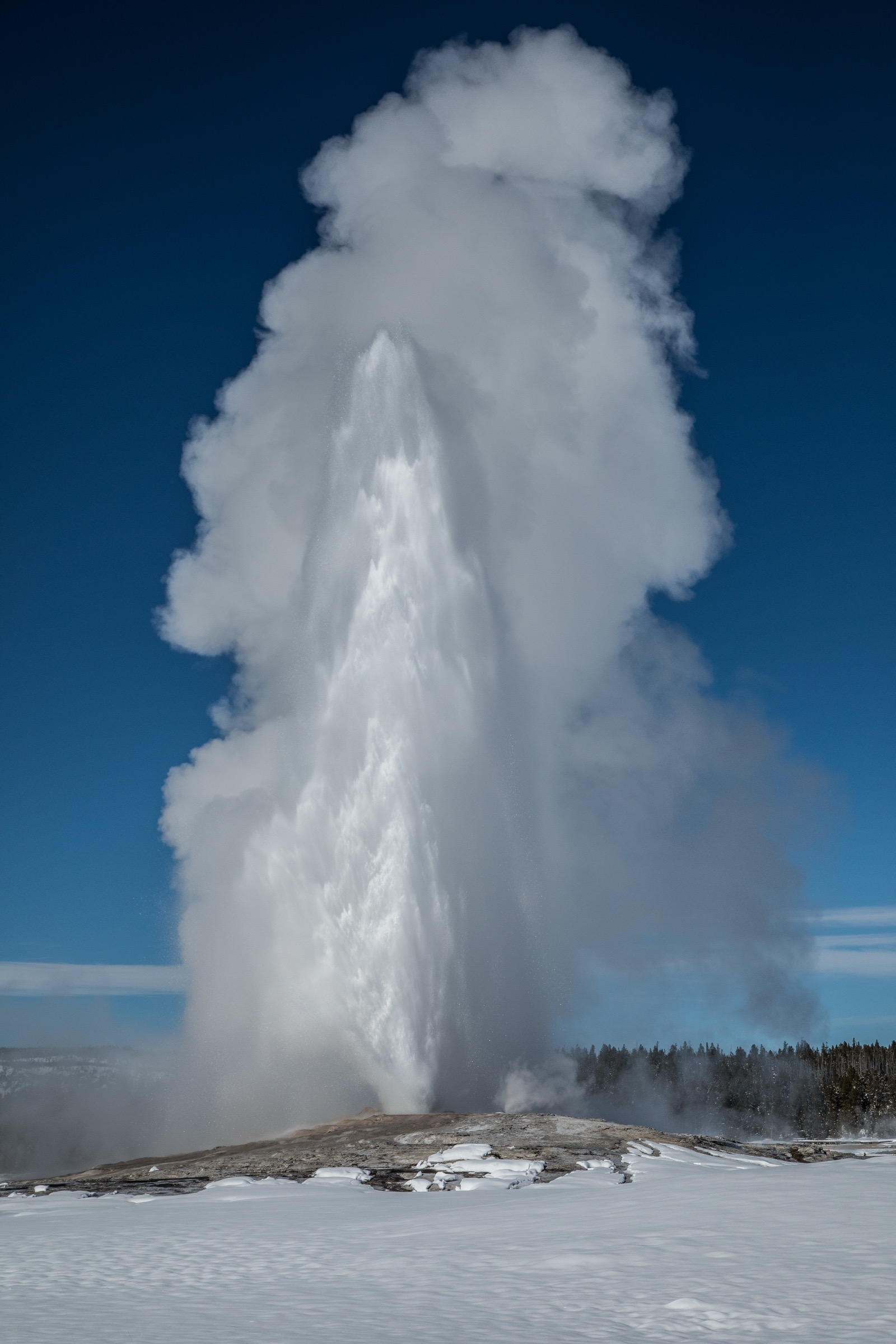
You already know what the tall white column is. Look at the ground instead. One part of it is not doing what the rest of the ground is doing — find it, and tell me why.
02. Engaging with the story · 10 min
Show photographs 4 through 7 in order. Give students a specific job before you start. If the park came up in step 1, name it now and move on: Yellowstone National Park. Most will have heard of it. Very few will have connected it to energy.
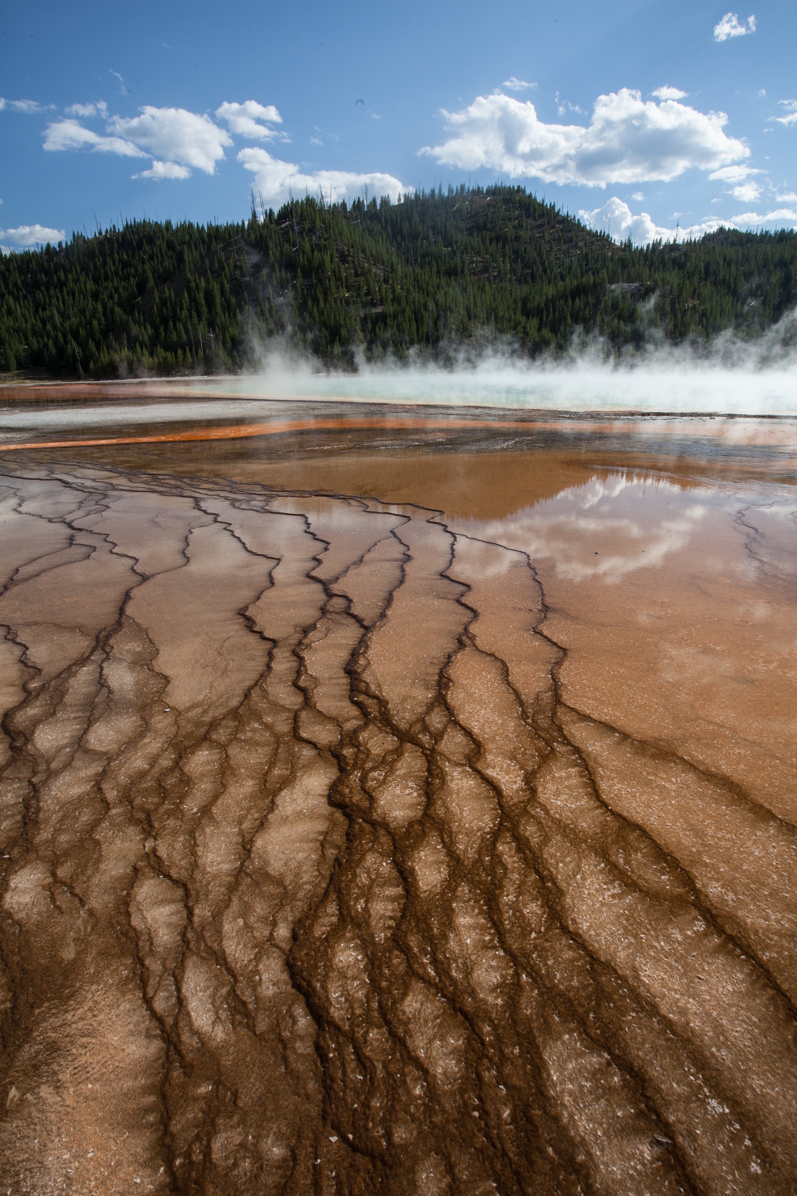
Keep a running list of every material you can identify. Not what you think is happening. Just the stuff: rock, water, vapor, deposits, color, anything alive, anything built by people.
03. Working the evidence · 15 min
The core of the investigation. Students work in pairs on the handout, using the Observe, Reflect, Question structure the Library of Congress developed for reading primary sources. A photograph is a primary source, and this is how it is done. Put photograph 3 on screen and leave it there.
Observe (5 minutes). Record only what is visible. No explanations yet.
- What do you notice first?
- What materials, textures and colors can you see?
- How is the scene arranged? What is near, what is far?
- Look again for a full silent minute. What did you miss?
Reflect (6 minutes). Now generate and test explanations.
- What do you think is happening here?
- What would have to be true underground for this to appear at the surface?
- The orange runs down the middle and fades outward. What could make a color do that?
- Compare photograph 3 with photograph 6. Same basin, twenty minutes apart. Why do they look so different?
- What is missing from these images?
Question (4 minutes).
- What do you wonder about: who, what, when, where, why, how?
- Standing there with any instrument you wanted, what would you measure first?
04. Delving deeper · 10 min
Now tell them what the orange is: living mats of heat-loving microbes, sorted along the cooling gradient, which makes the color of the ground a rough thermometer. Then hand out the data.
Read all three tables before you answer anything.
| Plant type | Reservoir temperature required | How it works | Where it stands in the US |
|---|---|---|---|
| Dry steam | About 400°F to 650°F (204°C to 343°C) | Steam from the reservoir turns the turbine directly | Known at only two US locations: The Geysers in California and Yellowstone. Only The Geysers operates. |
| Flash steam | About 400°F to 650°F, with water above roughly 360°F | Pressurized hot water flashes to steam as it rises. The steam drives the turbine. | The most common existing type in the US. |
| Binary cycle | About 200°F to 330°F (93°C to 166°C) | Geothermal water heats a second fluid with a lower boiling point. That fluid drives the turbine. | Nearly 90 percent of the 735 MW of US capacity built since 2000. |
| Measure | Value |
|---|---|
| Total generation | About 16 billion kilowatt-hours |
| Share of US utility-scale electricity | About 0.4 percent |
| States with geothermal plants | 7 |
| California | About 69 percent of US geothermal generation |
| Nevada | About 25 percent |
| Utah | About 3 percent |
| Year | Law | What it does |
|---|---|---|
| 1970 | Geothermal Steam Act | No geothermal leasing inside national parks |
| 1988 | Geothermal Steam Act Amendments | Blocks leasing in the Island Park area outside Yellowstone, and requires protection of designated “significant thermal features” in 16 park units |
| Ongoing | BLM regulations, 43 CFR 3200 | No leases where operations are likely to cause significant adverse effects to those features |
05. Reflecting and projecting · 15 min
The claim, evidence and reasoning assignment. Two parts. Both appear on the student handout as Part A and Part B.
Part A. Read the evidence. Based on the photographs alone, what can you conclude about the heat and water beneath this place, and what can you not conclude?
Part B. Make the call. A member of Congress proposes opening a portion of the land just outside Yellowstone to geothermal leasing. Should it happen?
- Your claim. State your position in one or two sentences.
- Your evidence. At least two specific observations from the photographs, plus one item from Tables 1, 2 or 3. Name the source of each.
- Your reasoning. Explain the scientific and practical principles that connect your evidence to your claim.
Students may submit as a written paragraph, a recorded verbal explanation, an annotated photograph, or a labeled diagram. All four are acceptable and the rubric applies equally.
06. Take action · 15 min
Ninety-minute path only. Students choose one option.
Choose one.
- Your state’s heat. Does your state generate geothermal electricity? Where are its heat resources mapped? If it has none, find the nearest state that does and what makes it different.
- The Utah question. Companies in Utah are building enhanced geothermal projects that do not rely on natural hot springs at all. They drill into hot dry rock and create the fractures themselves. Research one. What problem does it solve, what are people worried about, and does it change your answer to question 6?
- What else is protected. Sixteen National Park Service units have designated significant thermal features. Find another one. What is protected there, and what would be lost if it were not?
07. The rebuttal · 15 min
At 90 minutes, add the rebuttal to the claim-evidence-reasoning assignment.
Your rebuttal. Someone reaches the opposite conclusion from the same evidence. State their position as fairly as you can, then explain why the evidence favors yours. If you think the evidence does not settle it, say so and explain what would.
Discussion questions and strong responses
What is the white and gray crust in photograph 3, and where did it come from?
Sinter, which is silica. Hot water dissolved silica from rock underground, and when it reached the surface and cooled and lost pressure the silica came out of solution and built up as crust. Accept any answer with the right sequence: dissolved underground, deposited at the surface.
The steam is not smoke and nothing is burning. What is rising, and what made it change from liquid to gas?
Water vapor. Groundwater was heated under pressure well past its normal boiling point and stayed liquid because of that pressure. As it rose the pressure dropped and it flashed to steam. Strong answers mention pressure, not just temperature.
Why is the orange brightest in the middle of the channel and faded at the edges?
Because the color is made by living microbes that each tolerate a narrow temperature range. The channel center is hottest and supports one community; the water cools as it spreads outward, so different species with different pigments take over. The color is tracking temperature.
Photograph 7 was taken twenty miles north of the geyser basins and looks completely different. The white there is calcium carbonate, not silica. What does that tell you about the rock underground in the two places?
That the rock is different. At Mammoth the water is moving through limestone and carrying dissolved calcium carbonate; in the geyser basins it moves through volcanic rock and carries silica. Same heat, same process, different local geology, so a completely different landform.
Binary cycle plants work at much lower temperatures than flash plants, and almost all new US plants are binary. Why would a company choose the design that produces less power per plant?
Because a binary plant can be built in far more places. A company that can only build where rock exceeds 400°F has very few options. A lower-temperature design that works in more locations may deliver more total electricity even if each plant produces less. Strong answers frame it as a trade between per-plant output and number of viable sites.
Open question. Yellowstone is one of only two known dry steam resources in the country, and it is illegal to develop. Was that the right call?
Answers vary and should. A strong case for protection notes that the features are rare, that drilling nearby can drain or depressurize a hydrothermal system, that the park’s value is partly economic through tourism, and that 0.4 percent of national generation is not worth an irreplaceable landscape. A strong case against notes that the resource is genuinely first-rate, that leasing outside the boundary is not the same as drilling inside it, and that a country serious about low-carbon electricity should weigh that. The best answers name what evidence would change their mind.
Answer key
Sample strong responses for each discussion question are held with the question itself. What follows is guidance the answers share.
- Questions 1 and 2 are scored on SEQUENCE, not vocabulary: dissolved underground then deposited at the surface; heated under pressure then flashed as pressure dropped.
- Question 3 is the one the lesson has been withholding. A student who answers it with “minerals” or “rust” has not had the step 4 reveal, or did not believe it.
- Question 6 has no key. Score the reasoning and the willingness to name disconfirming evidence, never the position.
Scoring guide
- Claim
- Developing — restates the question or is too vague to evaluate
- Proficient — clear and directly answers the question
- Advanced — precise and appropriately limited about what it does and does not settle
- Evidence
- Developing — one vague reference to the images
- Proficient — two or more specific observations correctly described, plus a data point, with sources named
- Advanced — evidence selected because it is relevant, not just because it was available
- Reasoning
- Developing — restates evidence in different words
- Proficient — names the relevant principle and connects it to the claim
- Advanced — explains why the principle applies here and where it stops applying
- Rebuttal (90-minute path)
- Developing — absent, or dismisses the alternative
- Proficient — states an alternative and answers it with evidence
- Advanced — represents the alternative fairly enough that its holder would accept the summary, then answers it
Common misconceptions
Many students believe geothermal energy comes from lava directly, and that plants therefore only work near volcanoes. The correction: the heat source is hot rock, not molten rock, and what a plant needs is a working circulation system of water and fractures. That is also what makes enhanced geothermal significant.
A second common error. Students describe the steam as smoke. Ask what would have to be burning.
Sources
- Use of geothermal energy — U.S. Energy Information Administration, 2025 data. https://www.eia.gov/energyexplained/geothermal/use-of-geothermal-energy.php
- Most U.S. utility-scale geothermal power plants built since 2000 are binary-cycle plants — U.S. Energy Information Administration. https://www.eia.gov/todayinenergy/detail.php?id=44576
- Geothermal Electricity Production Basics — National Renewable Energy Laboratory. https://www.nrel.gov/research/re-geo-elec-production.html
- Geothermal Legal Instruments — National Park Service. https://home.nps.gov/articles/geothermal-legal-instruments.htm
- Information Technology and Innovation Foundation, “Advanced Geothermal Energy Is Widely Available, Clean, and Maybe Cheap Enough to Make a Big Impact,” May 2026.
- Library of Congress, “Teacher’s Guide: Analyzing Photographs and Prints.”
- NGSS performance expectations HS-ESS2-3, HS-ESS3-1, HS-ESS3-2.
- The Inquiry Atlas. (2026). Where the Earth Leaks Heat: a Visual Field Investigation. Photography by Greg Smith.