Teacher guide
What Water Leaves Behind
What can running water tell us about the land it moves through, and how should we share what is left?
Print this guide
At a glance
- Grades
- 9-10, 11-12
- Subjects
- Earth Science, Environmental Science
- Time
- 45 minutes core. 15-minute and 90-minute paths included.
- Preparation
- light
- Standards
- HS-ESS2-5, HS-ESS3-1, HS-ESS3-4; CCSS.ELA-LITERACY.RST.9-10.7, CCSS.ELA-LITERACY.WHST.9-12.1
- Materials
- Projector or student devices, Student handout, Pencil
Notes on standards alignment
HS-ESS2-5
That performance expectation asks students to plan and conduct an investigation. This lesson has them analyse photographic evidence and a supplied data set, which supports the DCI and the crosscutting concept but does not on its own meet the practice. If you need the full PE, pair this investigation with a stream-table or sediment-transport lab; the observations students make here are a good design brief for one.
Prior knowledge
Students should already know that water moves downhill under gravity, that the water cycle moves water between ocean, air, land and ice, and that moving water can carry material. They do not need any prior exposure to fluvial geomorphology.
If your class has not covered the water cycle, spend three minutes on it before you begin.
Key vocabulary
- Discharge
- The volume of water passing a point in a river each second. It is what a hydrologist means by “how much water”.
- Drainage basin
- All the land whose water drains toward one river. Also called a watershed.
- Groundwater
- Water held in the pores and cracks of rock and soil below the surface.
- Spring
- A place where groundwater reaches the surface on its own, without being pumped.
- Snowpack
- Snow that builds up through a cold season and melts later. It works as a reservoir that nobody had to build.
- Abrasion
- The wearing away of rock by sediment carried in moving water. The water does far less of this than the sand and gravel it is carrying.
- Plunge pool
- The basin a waterfall excavates at its own base.
- Knickpoint
- A sudden step in a river’s downstream profile. A waterfall is one, and it moves upstream over time.
- Sediment load
- Everything a river is carrying: dissolved, suspended in the water, and rolling along the bed.
- Perennial and ephemeral
- A perennial stream flows all year. An ephemeral one flows only after rain or melt.
Background for the teacher
A photograph of moving water establishes quite a lot, and less than students assume. It establishes that water is moving, in what direction, and roughly how energetically. It establishes where water goes and where it does not, because the difference is written in the rock color and in where anything green is able to grow. It establishes that the process has been running for a long time, because falls, pools and canyons take time to cut. What it does not establish is how much water, how reliably, or for how long. Those are measurements, and they are exactly the ones every downstream decision depends on.
Photograph 1 is the case worth dwelling on. The rock the water is not touching is bare and pale, the woody plants are leafless and sparse, and the green growth stops within centimeters of the water. A place that received regular rain would not look like that. So the water is arriving some other way.
The usual answer is groundwater. Rain and snowmelt that fell somewhere else, often higher and often years or decades earlier, soaks into permeable rock, travels underground, and emerges where the geology forces it to the surface. A spring is that emergence. This is why a desert can contain permanent water while receiving almost none: the water in the frame is not this year’s weather, it is a slow withdrawal from an underground account filled elsewhere. For scale on how dry “dry” can be, the National Park Service gives Death Valley an average annual rainfall of “less than 2 inches (5 cm)”, with the Furnace Creek record at 1.94 inches.
Three processes cut rock, and students usually credit the wrong one. Abrasion is the main one: sediment carried in the current — sand, gravel, cobbles — strikes the bed and the walls and chips them away, while clear water does comparatively little. That is worth saying out loud, because “the water wears the rock away” is the phrase students arrive with, and it puts the work in the wrong place. The river is a conveyor belt, and the tools on it are doing the cutting. Hydraulic action is the force of the water itself, prising open cracks and driving air into them; it matters most where the rock is already fractured. Dissolution matters where the rock is soluble — limestone most of all — and leaves no sediment behind, which is why some water-carved landscapes are conspicuously clean.
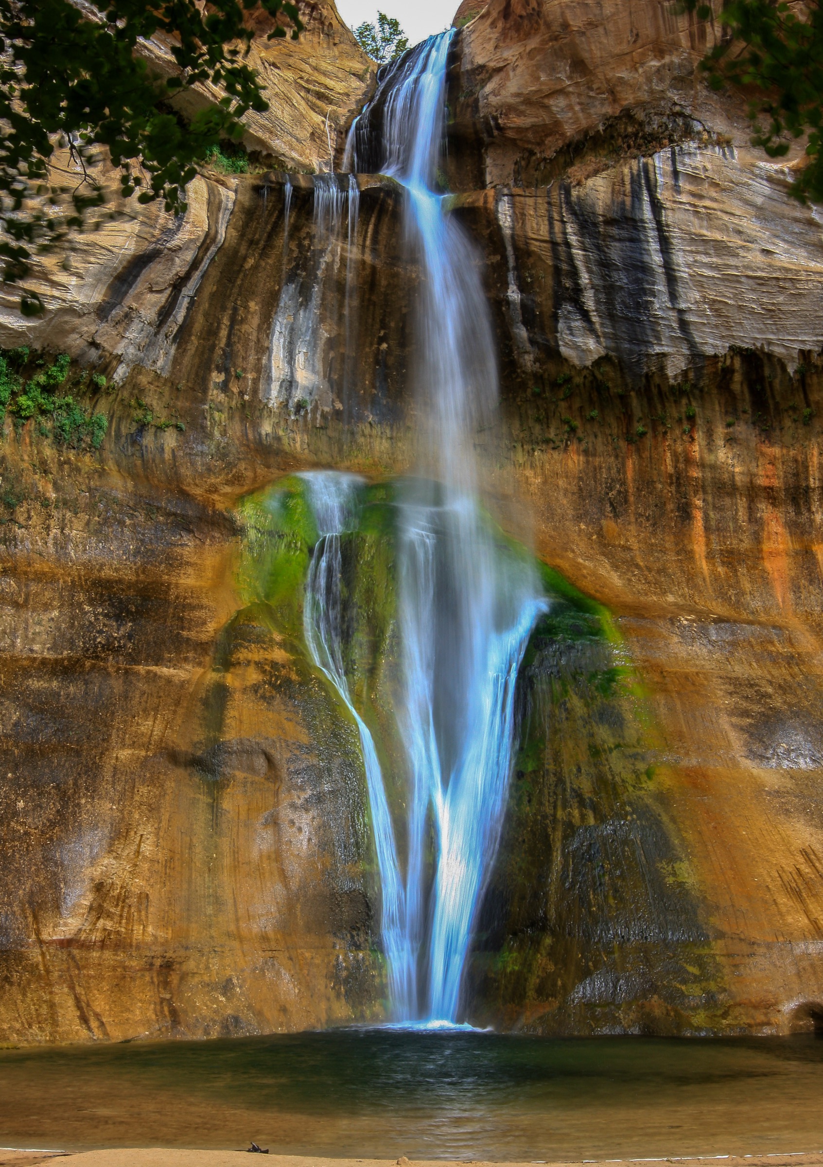
A plunge pool is the clearest illustration available. Falling water drives sediment in a circular motion at the base of a fall, and that sediment grinds a basin into the bed. The pool is not a side effect of the waterfall; it is the tool the waterfall built. Photographs 1 and 3 both show one. And because the pool undercuts the step, the step eventually collapses forward and the whole waterfall retreats upstream. A waterfall is a knickpoint, and knickpoints migrate — the waterfall in any photograph is not where it started and is not where it will be.
Photograph 5 is there for time. The raft gives a scale of a few meters; the cliff above it is hundreds. The National Park Service puts the Colorado River’s carving of the Grand Canyon at “beginning just 5-6 million years ago”, and describes the river’s 277-mile journey through it — while the oldest exposed rock in the inner gorge dates to “almost two billion years ago”. The rock is vastly older than the canyon. The river did not make the rock; it removed the rest of it. The canyon is the absence, and everything that was there is somewhere downstream.
In much of the western United States the water supply is a snowpack. The USGS puts it plainly: “As much as 75 percent of water supplies in some western states are derived from snowmelt”, and describes mountain snowfields as “natural reservoirs” that “store precipitation from the cool season when most precipitation falls, and release some or all of it during the warm season”. That reframes photograph 4 completely. A stream buried under snow is not a stream that has stopped. It is a stream whose water is sitting upslope waiting for spring, in a reservoir nobody had to build, pay for, or get permission to fill. Whether that stream is doing less geological work in winter, or the same work compressed into the melt season, is a real question and needs discharge records to answer. Do not settle it for students.
Students routinely overestimate how much fresh liquid water exists. The USGS figures: the oceans hold about 96.5 percent of all Earth’s water. Ice caps and glaciers are 1.74 percent of the total, and hold 68.7 percent of all fresh water. Groundwater is 1.69 percent of the total and 30 percent of fresh water. Rivers — every river on the planet — come to “about 1/10,000th of one percent of total water”. Every river in every photograph in this lesson is part of that last line.
The Bureau of Reclamation describes the Colorado River as “approximately 1,400 miles long”, draining “approximately 250,000 square miles” across “seven U.S. states—Arizona, California, Colorado, Nevada, New Mexico, Utah, and Wyoming”. It says “between 35 and 40 million people rely on the same water for some, if not all, of their municipal needs”, that “agricultural uses depend on 70 percent of Colorado River water”, and that “Long-term drought has reduced Colorado River system storage to about 36 percent of capacity”. That is a river that was divided up on the basis of how much water people believed it carried, and is now being managed on the basis of how much it actually carries. The difference is the whole argument.
One more link is worth having, because it connects this lesson to the wind and deserts investigation. Dust blown off disturbed dryland soils settles on mountain snow and darkens it; darker snow absorbs more sunlight and melts earlier. Painter et al. (2010) found that “peak runoff at Lees Ferry, Arizona has occurred on average 3 wk earlier under heavier dust loading”, and that runoff decreased “by more than 1.0 billion cubic meters or ≈5% of the annual average”. They attribute it to a “fivefold increase in dust loading from anthropogenically disturbed soils in the southwest United States” already under way “by the late 1800s, decades prior to allocation of the river’s runoff in the 1920s”. So the river was divided up using flow records that had already been altered by land use hundreds of miles away. Students who get to that point on their own have done something real.
The photographs
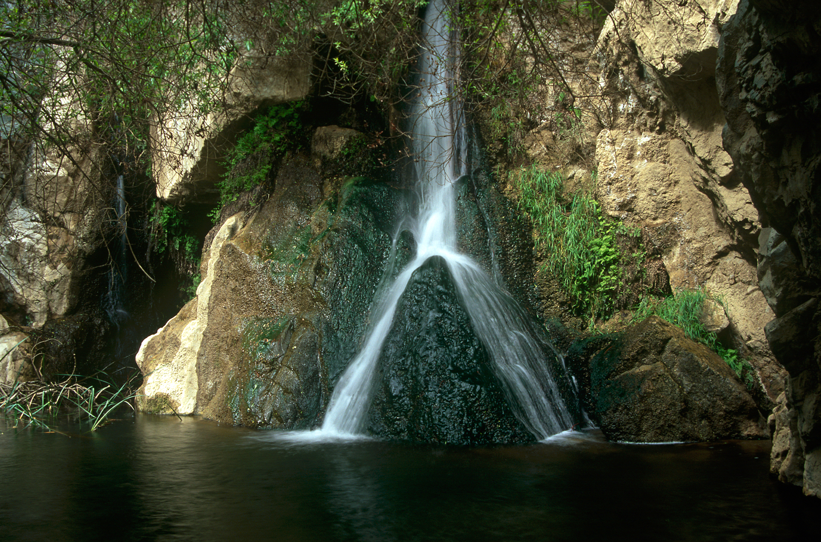
1. anchor Water drops down a face of dark, wet rock into a still pool. Everything the water is not touching is bare: pale rock, dry branches, no soil worth the name. The green is confined to a narrow band exactly where the water runs, which is the first thing worth noticing and the last thing students notice. 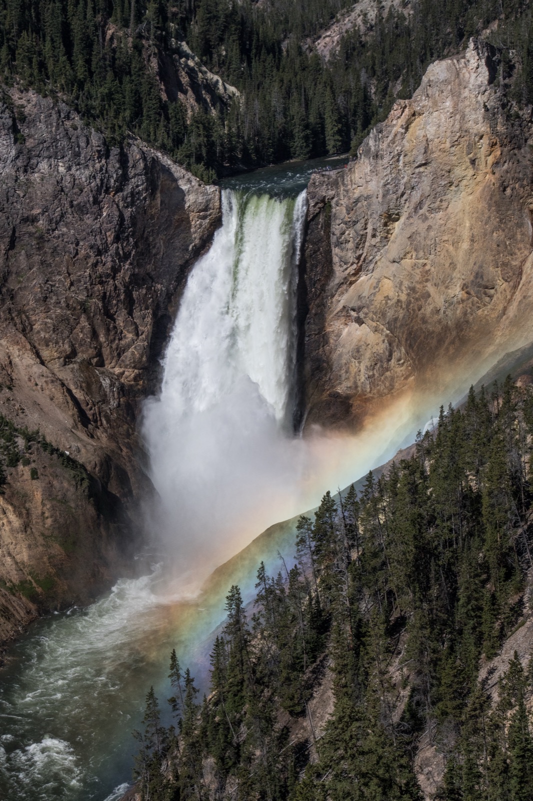
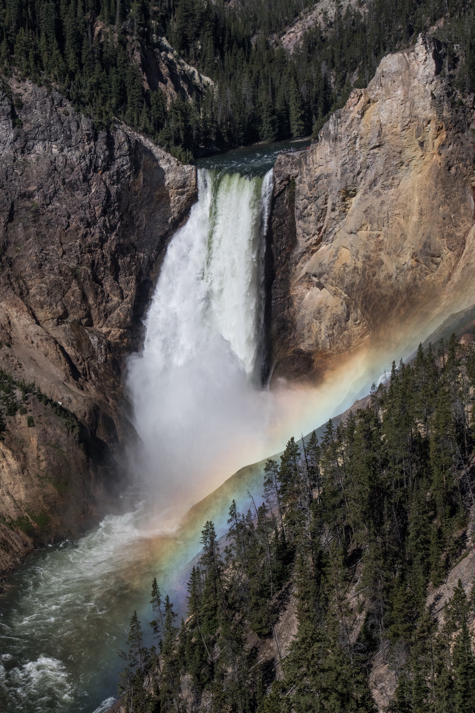
2. context The same process at a scale that will not fit in one glance. A large river drops over a hard step into a canyon it has cut through hundreds of meters of rock. The rainbow standing in the air below the fall is a measure of how much water is being thrown into the air, and how hard. 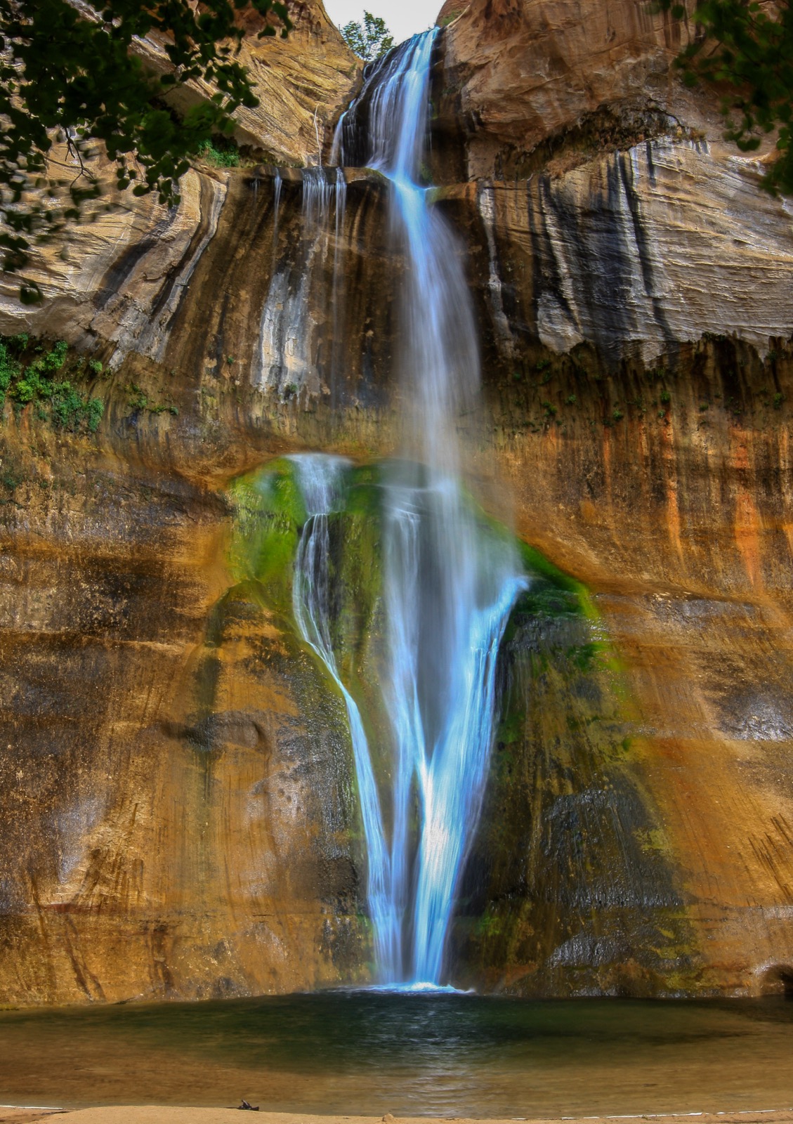
3. detail A fall on a sandstone wall, with three things worth reading in one frame: the dark vertical streaks where water has run down the rock for a very long time, the green growing only in the wet zone, and the shallow pool with a sand beach at the bottom — sand that used to be part of the wall. 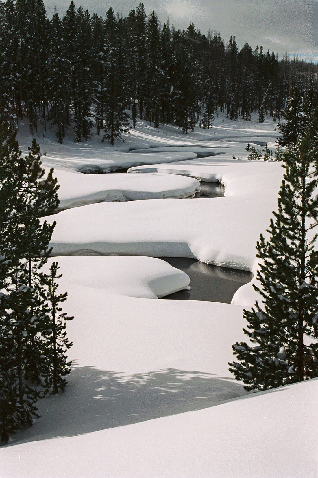
4. comparison The same kind of stream, in the season when it appears to be doing nothing. Snow has buried the channel except for a few dark gaps of open water. Whether the stream is working less, or working on a different schedule, is the question — and the photograph cannot settle it. 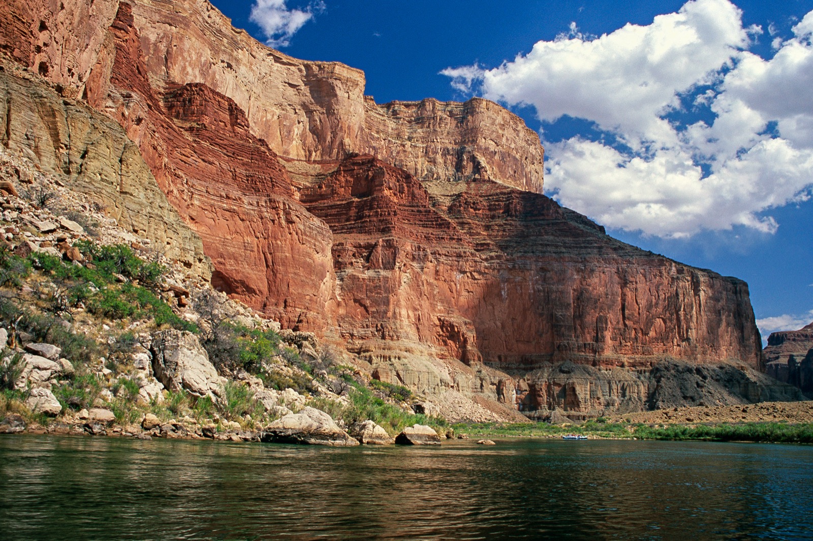
5. human-scale A raft with people in it, near the far bank, against a cliff of layered rock. The raft is a few meters long. Use it to measure the cliff, then ask which of the two the river made.
01. Setting the stage · 5 min
Project photograph 1 with no title, no caption and no context. Say nothing about it. Ask two questions, take four or five answers, and do not confirm or correct any of them. Write the guesses on the board, and write the rainfall numbers next to them.
You are looking at a place in the United States. Where do you think this is — and how much rain do you think it gets in a year?
02. Engaging with the story · 10 min
Show photographs 2 through 5 in order. Give students a job before you start. If Greg’s field account has been recorded, read it aloud while the images are on screen. If it has not, give students a silent minute with each frame instead.
Keep a running list of every place in these images where water clearly goes, and every place it clearly does not. Not what you think is happening. Just where the water is and is not.
03. Working the evidence · 15 min
The core of the investigation. Students work in pairs on the handout, using the Observe, Reflect, Question structure the Library of Congress developed for reading primary sources. A photograph is a primary source, and this is how it is done. Put photograph 1 back on screen and leave it there.
Observe (5 minutes). Record only what is visible. No explanations yet.
- What do you notice first?
- What materials, textures and colors can you see?
- Where exactly is the green, and where exactly is it not?
- Look again for a full silent minute. What did you miss?
Reflect (6 minutes). Now generate and test explanations.
- What do you think is happening here?
- Look at the rock the water is not touching. What does it tell you about how much rain this place gets?
- If it does not rain much here, where is this water coming from?
- Compare photograph 1 with photograph 3. Both show water falling onto rock with a pool at the bottom. What is the pool doing?
- What is missing from these images?
Question (4 minutes).
- What do you wonder about: who, what, when, where, why, how?
- Standing there with any instrument you wanted, what would you measure first?
04. Delving deeper · 10 min
Now name the mechanism: much of the permanent water in dry country is groundwater, recharged somewhere else and often long ago, reaching the surface where the geology forces it out. Then hand out the data.
Read all three tables before you answer anything.
| Where | Share of all Earth’s water | Share of fresh water |
|---|---|---|
| Oceans | About 96.5 percent | — |
| Ice caps and glaciers | 1.74 percent | 68.7 percent |
| Groundwater | 1.69 percent | 30 percent |
| All rivers | About 1/10,000th of one percent | — |
Source: U.S. Geological Survey, Water Science School.
| Measure | Value |
|---|---|
| Share of water supply from snowmelt, in some western states | As much as 75 percent |
| What a snowpack does | Stores cool-season precipitation and releases it in the warm season — a reservoir nobody had to build |
| Effect of heavier dust settling on that snow | Peak runoff at Lees Ferry, Arizona arrives on average 3 weeks earlier |
| Effect on the year’s total runoff | Reduced by more than 1.0 billion cubic meters, about 5 percent of the annual average |
| When the dust increase began | A fivefold increase from disturbed soils was already under way by the late 1800s |
Sources: U.S. Geological Survey; Painter et al., PNAS, 2010.
| Measure | Value |
|---|---|
| Length | About 1,400 miles |
| Basin area | About 250,000 square miles |
| States it serves | Arizona, California, Colorado, Nevada, New Mexico, Utah, Wyoming |
| People relying on it | Between 35 and 40 million, for some or all of their municipal water |
| Share used by agriculture | 70 percent |
| System storage today | About 36 percent of capacity, after long-term drought |
Source: U.S. Bureau of Reclamation, Colorado River Basin.
05. Reflecting and projecting · 15 min
The claim, evidence and reasoning assignment. Two parts. Both appear on the student handout as Part A and Part B.
Part A. Read the evidence. Based on the photographs alone, what can you conclude about the water in these places? And just as important, what can you not conclude?
Part B. Make the call. A water district that draws from a snow-fed river has applied to increase its annual withdrawal by 10 percent. The river’s flow changes from year to year with the snowpack, and the water already promised to existing users adds up to more than the river has carried in recent years. Should the state approve the increase?
- Your claim. State your position in one or two sentences.
- Your evidence. At least two specific observations from the photographs, plus one item from Tables 1, 2 or 3. Name the source of each.
- Your reasoning. Explain the scientific and practical principles that connect your evidence to your claim.
Students may submit as a written paragraph, a recorded verbal explanation, an annotated photograph, or a labeled diagram. All four are acceptable and the rubric applies equally.
06. Take action · 15 min
Ninety-minute path only. Students choose one option.
Choose one.
- Your own water. Where does the water from your tap come from? Name the source, the watershed, and how far it travels. If it is groundwater, find out how long ago it fell as rain.
- The snow line. Find the snowpack record for the mountain range nearest you, or the nearest one that has one. What has it done over the last thirty years, and who depends on it?
- Dust and snow. Read about dust deposited on mountain snow. Where does the dust come from, what does it do to melt timing, and does it change your answer to question 6?
07. The rebuttal · 15 min
At 90 minutes, add the rebuttal to the claim-evidence-reasoning assignment.
Your rebuttal. Someone reaches the opposite conclusion from the same evidence. State their position as fairly as you can, then explain why the evidence favours yours. If you think the evidence does not settle it, say so and explain what would.
Discussion questions and strong responses
In photograph 1, look at the rock the water is not touching. What does its color and its plant cover tell you about how much rain this place gets?
That it gets very little. The rock away from the water is pale, bare and dusty rather than darkened, stained or covered in growth; the woody plants are leafless and widely spaced; and there is no soil layer or leaf litter visible. Somewhere with regular rainfall would have growth spread across the whole frame, not confined to a band at the waterline. Accept any answer that reasons from the DISTRIBUTION of the green rather than from its presence.
Photographs 1 and 3 both show water falling onto rock with a pool at the bottom. What is the pool doing to the rock?
Digging it. Falling water drives sand and gravel in a circular motion at the base of the fall, and that sediment grinds a basin into the bed — a plunge pool. Strong answers say the sediment is doing the cutting, not the water. The strongest go one step further: because the pool undercuts the step, the waterfall eventually collapses forward and moves upstream.
In photograph 2 a rainbow stands in the air below the falls. What has to be in the air for that to happen, and what does it tell you?
Water droplets, in very large numbers, suspended in air with sunlight behind the observer. To throw that much water into the air, the falling water has to be losing a great deal of energy very quickly. The rainbow is indirect evidence of the size of the drop and the volume of flow. Accept any answer connecting suspended droplets to energy released at the base of the fall.
Photograph 4 shows almost no moving water. Is that stream doing less work than the others, or the same work at a different time?
The honest answer is that the photograph cannot tell you, and saying so is the strongest response available. What can be argued: the water is not gone, it is stored as snow upslope, and it will arrive later and probably faster. Most of a mountain stream’s geological work is done during high flows, so a stream that looks inactive in February may do more work in six weeks of May than in all the rest of the year. Settling it would need discharge records. Award full credit for a student who names the measurement they would need.
In photograph 5 the raft is a few meters long and the cliff is hundreds of meters high. Which of those two did the river make?
Neither, exactly — and that is the point. The river did not build the cliff; it removed everything that used to be between the two cliffs. The canyon is an absence. The rock layers were laid down long before, over a far longer period; the National Park Service dates the carving of the Grand Canyon to 5–6 million years ago against inner-gorge rock almost two billion years old. Strong answers name the difference between the age of the rock and the age of the canyon.
Open question. A river’s flow comes mostly from mountain snow, and the amount of snow varies from year to year. The water has already been promised to cities and farms. Who should go short in a dry year, and how would you decide?
Answers vary and should. A strong case for protecting agriculture notes that agriculture is about 70 percent of Colorado River use, that food supply is downstream of it, and that farms cannot easily restart after a fallow year. A strong case for protecting municipal supply notes that 35 to 40 million people rely on the river for municipal needs and that drinking water is not substitutable. A strong case for neither notes that the allocations were made against flow records that were already altered by upstream dust loading, so the promises exceeded the river before anyone signed them. The best answers name what evidence would change their mind.
Answer key
Sample strong responses for each discussion question are held with the question itself. What follows is guidance the answers share.
- Question 1 is scored on the DISTRIBUTION of the green, not its presence. A student who says “there are plants, so it rains” has read the wrong variable.
- Question 2 is scored on AGENCY: the sediment does the cutting, not the water. “The water wears it away” is the phrase students arrive with and is the one to push on.
- Question 4 has no settled answer and is not supposed to. The highest-scoring response names the measurement — discharge records — rather than picking a side.
- Question 6 has no key. Score the reasoning and the willingness to name disconfirming evidence, never the position.
The green growth in photographs 1 and 3 is deliberately not named as an organism anywhere in this investigation. If a student asks whether it is algae or moss, the honest answer is that a photograph cannot tell you — and that the useful question is what the distribution of the green says about where water stays.
Scoring guide
- Claim
- Developing — restates the question or is too vague to evaluate
- Proficient — clear and directly answers the question
- Advanced — precise and appropriately limited about what it does and does not settle
- Evidence
- Developing — one vague reference to the images
- Proficient — two or more specific observations correctly described, plus a data point, with sources named
- Advanced — evidence selected because it is relevant, not just because it was available
- Reasoning
- Developing — restates evidence in different words
- Proficient — names the relevant principle and connects it to the claim
- Advanced — explains why the principle applies here and where it stops applying
- Rebuttal (90-minute path)
- Developing — absent, or dismisses the alternative
- Proficient — states an alternative and answers it with evidence
- Advanced — represents the alternative fairly enough that its holder would accept the summary, then answers it
Common misconceptions
Most students believe the water itself does the cutting. The correction: the sediment does nearly all of it. Ask what a river with no sand or gravel in it would be able to erode, and how fast.
A second common error. Students treat a waterfall as a permanent landmark. Ask what the pool at the bottom is doing to the rock holding the fall up, and where the fall will be in ten thousand years.
A third. Students read photograph 4 as a stream that has stopped. Ask where the water in it has gone, and when it is coming back.
Sources
- How much water is there on Earth? — U.S. Geological Survey, Water Science School. https://www.usgs.gov/special-topics/water-science-school/science/how-much-water-there-earth
- Snowmelt runoff and the water cycle — U.S. Geological Survey, Water Science School. https://www.usgs.gov/special-topics/water-science-school/science/snowmelt-runoff-and-water-cycle
- Colorado River Basin — U.S. Bureau of Reclamation. https://www.usbr.gov/ColoradoRiverBasin/
- Response of Colorado river runoff to dust radiative forcing in snow — Painter, Deems, Belnap, Hamlet, Landry and Udall, Proceedings of the National Academy of Sciences, 2010. https://doi.org/10.1073/pnas.0913139107
- National Park Service, “Weather and Climate,” Death Valley National Park.
- National Park Service, “Geology,” Grand Canyon National Park.
- Library of Congress, “Teacher’s Guide: Analyzing Photographs and Prints.”
- NGSS performance expectations HS-ESS2-5, HS-ESS3-1, HS-ESS3-4.
- The Inquiry Atlas. (2026). What Water Leaves Behind: a Visual Field Investigation. Photography by Greg Smith.