Teacher guide
The Same Shape on Two Planets
What can a shape in the sand tell us about a force we cannot see — and what happens when we loosen the ground it comes from?
Print this guide
At a glance
- Grades
- 9-10, 11-12
- Subjects
- Earth Science, Environmental Science
- Time
- 45 minutes core. 15-minute and 90-minute paths included.
- Preparation
- light
- Standards
- HS-ESS2-1, HS-ESS2-2, HS-ESS3-1; CCSS.ELA-LITERACY.RST.9-10.7, CCSS.ELA-LITERACY.WHST.9-12.1
- Materials
- Projector or student devices, Student handout, Pencil
Notes on standards alignment
HS-ESS2-1
That performance expectation asks students to develop a model, and its wording targets continental and ocean-floor features. This lesson has students build a verbal and diagrammatic model of one surface process across four orders of magnitude of scale, which serves the DCI and the crosscutting concept squarely and the practice partially. If you need the full PE, have students draw the model rather than describe it.
Prior knowledge
Students should already know that moving air exerts a force on objects, that friction resists motion, that gravity pulls material down, and that Mars is a planet with a much thinner atmosphere than Earth’s. They do not need any prior exposure to aeolian geomorphology.
Key vocabulary
- Saltation
- The bouncing, skipping movement of sand grains along the ground when wind blows. Most of it happens within about a centimeter of the surface.
- Surface creep
- Grains too heavy to hop, nudged forward by other grains landing on them.
- Suspension
- Particles small enough for the air to hold up and carry away. This is dust.
- Ripple
- A small ridge in sand with its long axis across the wind, centimeters apart. The coarsest grains collect at the crest.
- Dune
- A mound or ridge of wind-blown sand, meters to hundreds of meters high, with a gentle upwind slope and a steep lee slope.
- Slipface
- The steep downwind side of a dune, where sand avalanches after being carried over the crest.
- Abrasion
- The wearing away of a surface by particles striking it.
- Ventifact
- A rock that has been cut, and sometimes polished, by wind-driven particles. Defined so students have the word. Whether photograph 3 shows one is a question in this lesson, not an answer.
- Albedo
- The fraction of sunlight a surface reflects. Fresh snow reflects most of it; dusty snow reflects much less.
- Threshold
- The wind speed at which grains of a given size start to move. Below it, nothing happens at all.
Background for the teacher
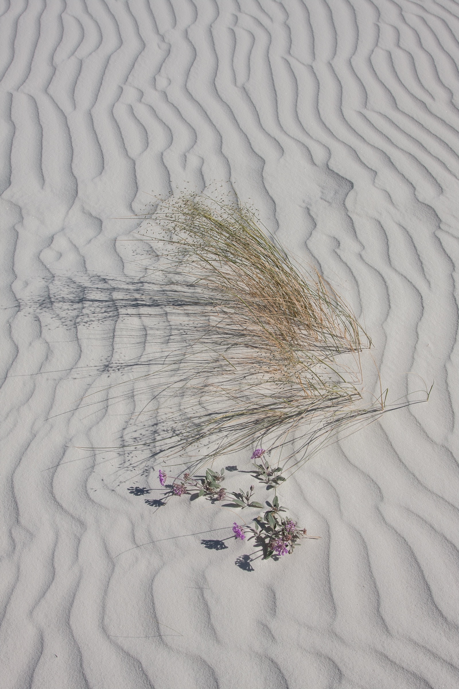
What a shape in sand records. Three things, readable directly. Direction: ripple crests form across the wind, so their long axes are perpendicular to the direction the wind was blowing — a photograph of ripples is a photograph of a wind direction. Grain size: the USGS puts the sorting plainly, “In ripples, the coarsest materials collect at the crests”, which is a sorting mechanism visible at arm’s length. And energy, relatively: spacing and height scale with how hard the wind has been working, so comparing regions of one photograph yields real information.
What a shape in sand does not record is when. Ripples reform in minutes. Photograph 1’s ripples are a record of the last strong wind, not of anything older.
Three ways wind moves material, and why grain size decides everything. From the USGS account of eolian processes: suspension, where “typical winds near the Earth’s surface suspend particles less than 0.2 millimeters in diameter and scatter them aloft as dust or haze” — once a particle is small enough, the air can hold it up indefinitely, and it leaves. Saltation, which “is downwind movement of particles in a series of jumps or skips”, and which “normally lifts sand-size particles no more than one centimeter above the ground, and proceeds at one-half to one-third the speed of the wind”. And surface creep — grains too heavy to hop, pushed along by grains landing on them — which “accounts for as much as 25 percent of grain movement in a desert”.
That one-centimeter figure is the most useful number in this lesson. It explains why wind-cut rock forms are low; why a fence post is undercut at its base and untouched at eye level; why photograph 3’s stone is lying on the ground where the sand is, rather than standing above it. Wind itself cuts almost nothing. The sand does the cutting, and the sand stays low. It also explains why dust is a different problem from sand: sand hops a short distance and settles nearby, while dust goes into suspension and travels for hundreds of miles, which is where this lesson ends up.
Ripples and dunes are not the same thing at two sizes. Students will assume they are, and the assumption is reasonable and wrong. The USGS description of a dune — “gentle upwind slopes on the wind-facing side” with a lee slope that is “commonly a steep avalanche slope referred to as a slipface” — describes a body of sand large enough to have its own airflow and to shed sand by avalanching. A ripple has no slipface and no avalanching; it is a surface texture produced by the impacts of saltating grains. The distinction has an observable consequence worth giving students: in ripples the coarse grains sit at the crest, and in dunes they do not. Same material, two different sorting mechanisms, two different features. Photographs 1 and 5 are the two ends of that range — centimeters and hundreds of meters, in the same set.
What it takes to build a dune field. Three things at once, which is why dune fields are rarer than deserts: a supply of loose sand, a wind that reliably exceeds the threshold, and something that makes the sand stop. The National Park Service account of Great Sand Dunes is a clean worked example of all three. “Creeks and streams brought in large amounts of sediment and sand into the valley” — supply. “Sand left behind blows with the predominant southwest winds toward a low curve in the Sangre de Cristo Mountains” — wind. And then the trap: “Wind then blew the sand toward the bend in the Sangre de Cristo Mountains, where opposing storm winds helped squeeze the sand into the tall dunes”, with the wind funnelling “toward three mountain passes here… and the sand accumulates in this natural pocket.” The result is the tallest dunes in North America at “741 feet / 226 meters.” That is the answer to “why here” for photograph 5, and the structure of the frame contains the whole argument: sand in front, mountains immediately behind.
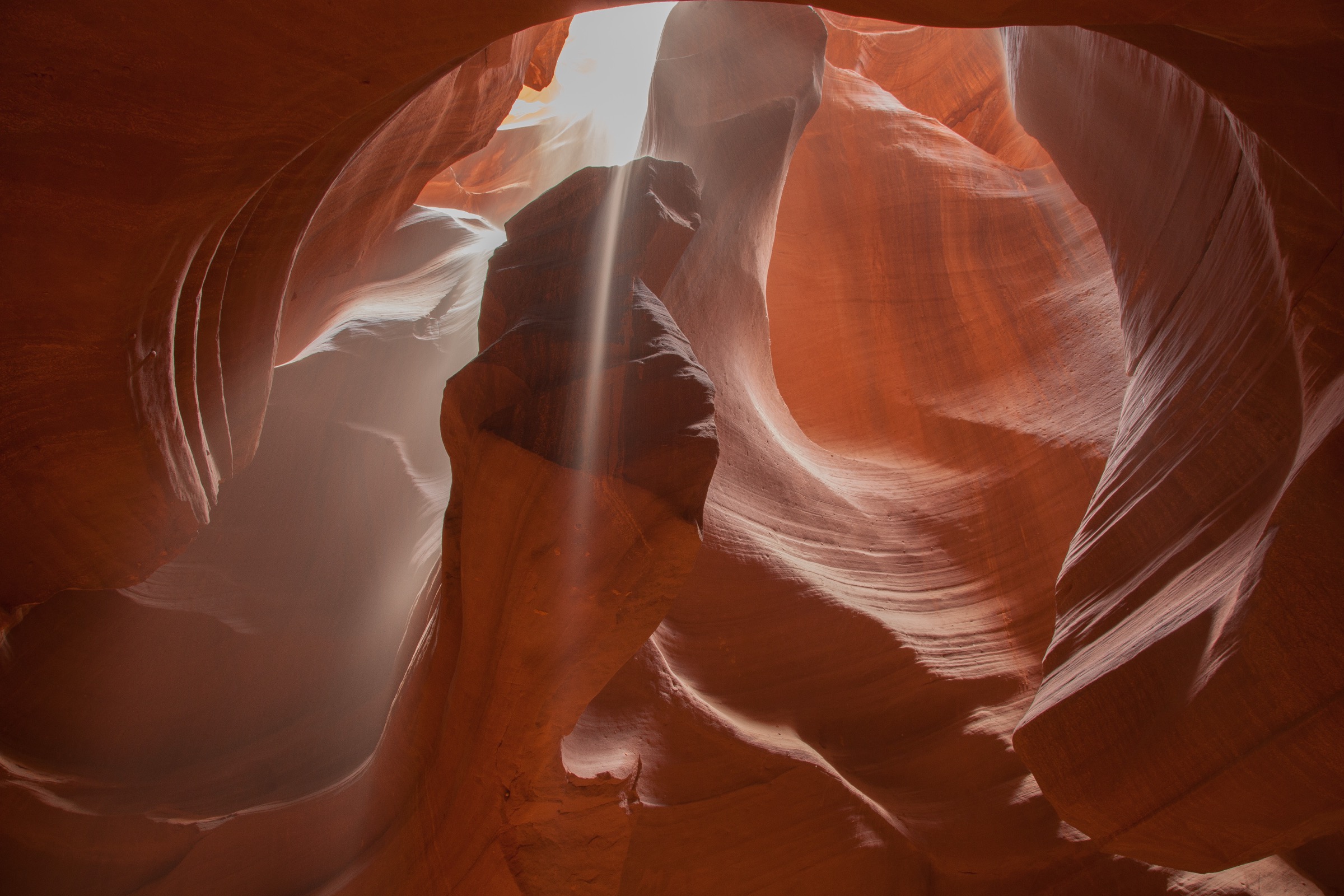
Photograph 2, and the discriminator students need. A narrow canyon with smooth, curved, layered walls invites “the wind did this”, and in a lesson about wind it invites it strongly. It is worth letting the class go there. The evidence runs the other way. Narrow canyons in sandstone country are cut by water, and specifically by flash floods: the National Park Service, describing exactly this kind of feature, says that while “many canyons are carved by rivers… the canyons in the monument are different; they were carved by flash floods”, and that “flowing water during flash floods has the power to move LOTS of rocks and sand.”
The reasoning that gets students there from the photograph runs in three steps. Saltating sand stays within about a centimeter of the ground, and these walls are sculpted from floor to far above head height — wind-carried sand does not reach that high in useful quantity. The sculpting is continuous and directional along the floor of the canyon, which is what a fluid confined in a channel does; wind in a slot is turbulent and would not produce that. And the rock is removed from a narrow, deep slot, so a great deal of material has gone somewhere — water carries it away in suspension and bedload, while wind would have to lift it out. The falling particles in the light beam are real and are wind-blown or disturbed sand. They are the trap: the one visibly wind-related thing in the frame is not what shaped it. Do not announce this. Photograph 2’s job is to be argued about.
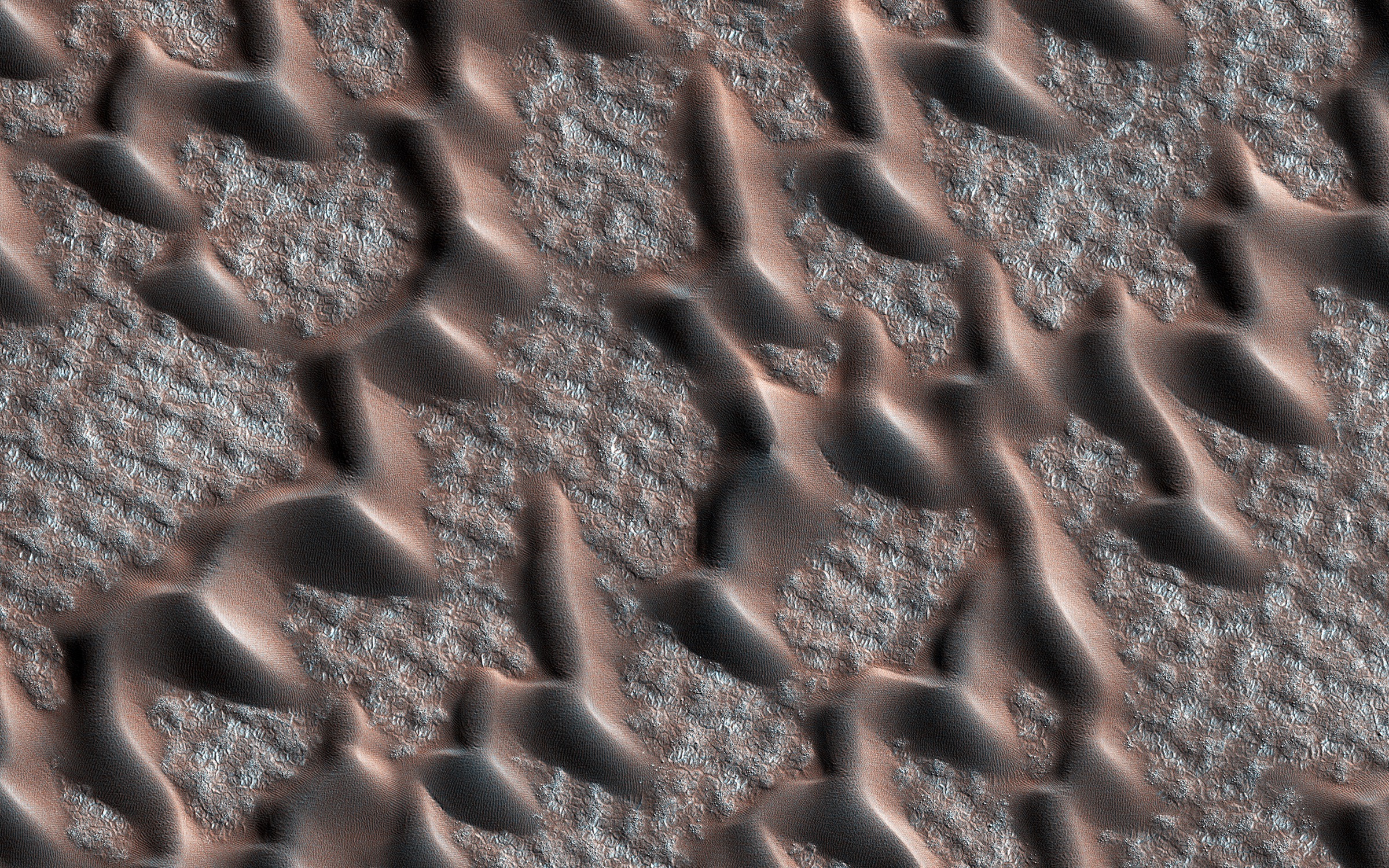
Mars: the same shapes, an atmosphere one percent as dense. The comparison frame is a HiRISE image of dunes near Mars’s permanent polar cap. Set the conditions out before asking what it means. Mars’s surface pressure is 6.36 mb against Earth’s 1014 mb; its surface density about 0.016 kg/m³ against 1.217; its surface gravity 3.73 m/s² against 9.82; its air 95.1 percent carbon dioxide against Earth’s 78.08 percent nitrogen. Thin air carries much less momentum, so it takes a far stronger wind to start a grain moving. For years it was an open question whether Mars’s dunes were fossils — shaped long ago and now static. They are not. NASA/JPL reported in 2012 that in the Nili Patera dune field “entire dunes as thick as 200 feet (61 meters) are moving as coherent units”, and that at one spot “more than two cubic yards (1,500 liters) of sand pass by in an Earth year.” JPL’s own framing of why that mattered: “This is unexpected because Mars has a much thinner atmosphere than Earth, is only about one percent as dense.”
The inference students should reach: a dune is what granular material does under a directional fluid flow, and that is a property of the process, not of Earth — the same physics produces the same forms wherever the ingredients exist. The inference they should not reach: that Mars therefore has Earth-like winds, or an Earth-like climate, or that the landscape is the same kind of place. The shapes match; the conditions producing them do not. A photograph of a Martian dune tells you the process ran. It does not tell you how hard, how often, or under what sky. This is the same limit as geo-001’s — surface evidence proves a process is operating and stays silent about its magnitude — arrived at from the opposite direction.
When the ground moves: dust, land use, and somebody else’s snow. Sand hops and settles nearby. Dust goes into suspension and leaves. When dryland soils are disturbed — by vehicles, by grazing, by anything that breaks the crust holding the surface together — more of them go into suspension. That dust settles out downwind, and some of it settles on mountain snow. Darker snow has a lower albedo, absorbs more sunlight, and melts earlier.
Painter et al. (2010, PNAS) measured the consequence for one river. “Peak runoff at Lees Ferry, Arizona has occurred on average 3 wk earlier under heavier dust loading.” Annual runoff decreased “by more than 1.0 billion cubic meters or ≈5% of the annual average”. And the timing matters as much as the size: “by the late 1800s, decades prior to allocation of the river’s runoff in the 1920s, a fivefold increase in dust loading from anthropogenically disturbed soils in the southwest United States was already decreasing snow albedo.” So the wind in these photographs is connected, through dust, to a river’s flow in another state — and the connection was already in place before anyone wrote down how much water that river had. That is the lesson’s decision, and it has the shape students find hardest and most worth practising: the cost falls a long way from the action, and on somebody else.
The photographs
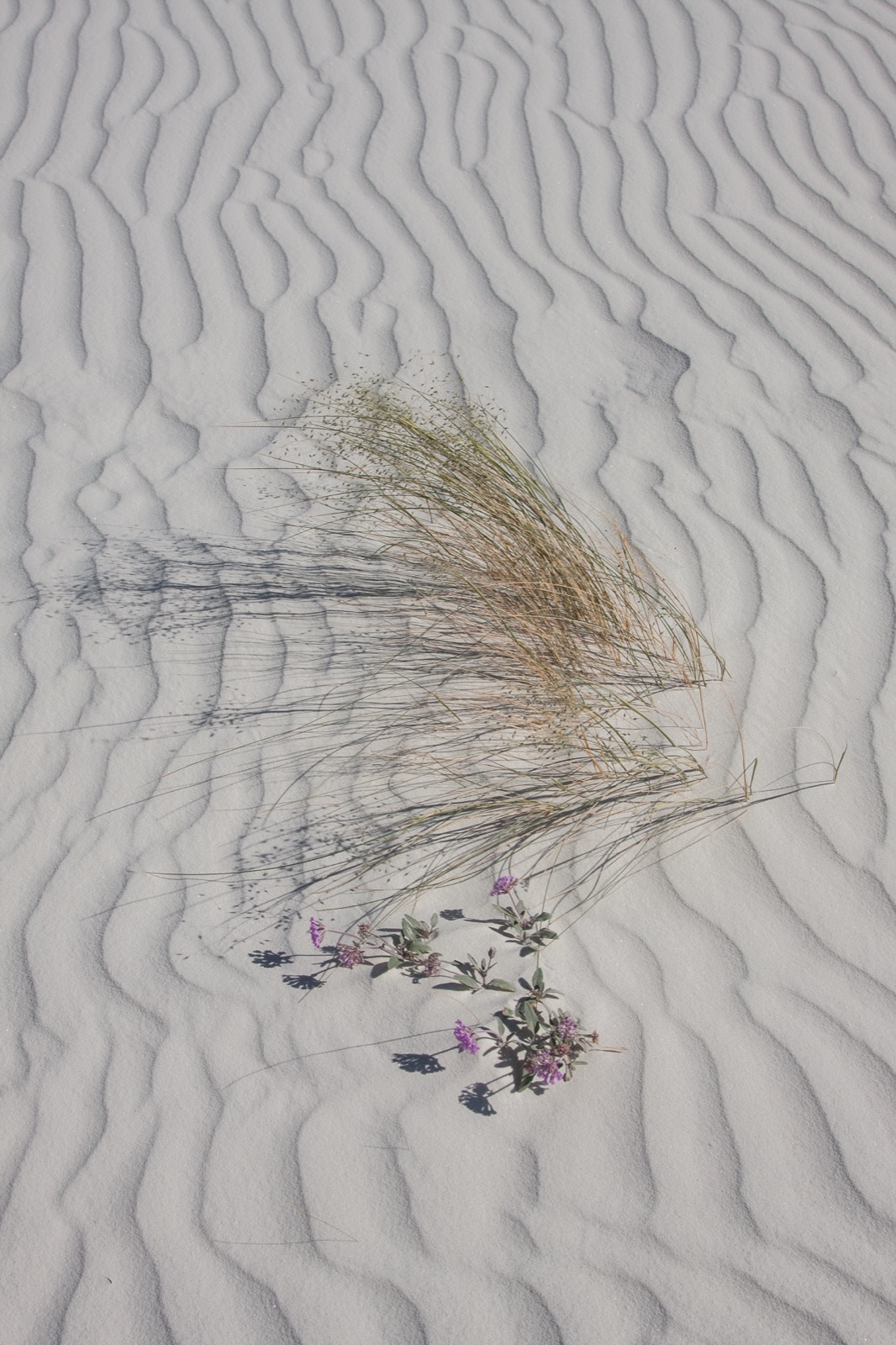
1. anchor Pale sand, ripple after ripple, and one clump of grass. Look at the ripple spacing — it is regular, and it changes where the grass sits. Look at the faint curved lines scratched into the sand beside the clump. Something drew them. The lesson starts by asking what. 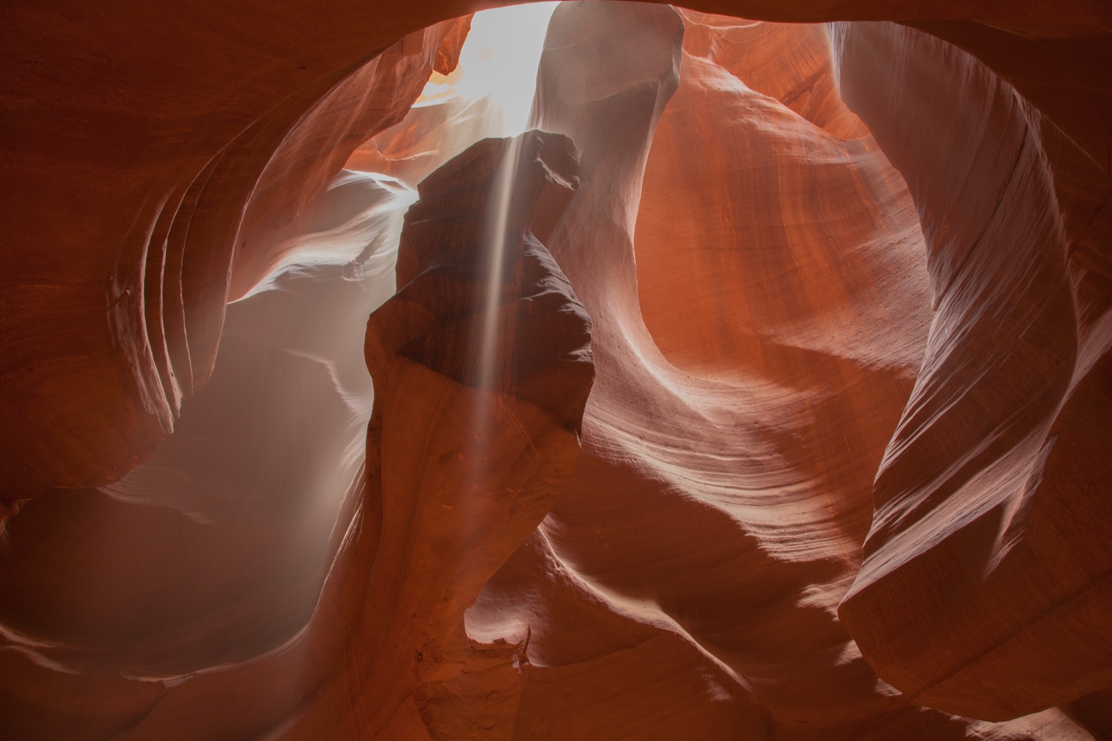
2. context A narrow canyon in orange rock, its walls smooth, curved and layered like something poured rather than broken. A single shaft of daylight comes in from a gap far above, and fine particles are falling through it. Two very different forces could have shaped this. Deciding which is the work. 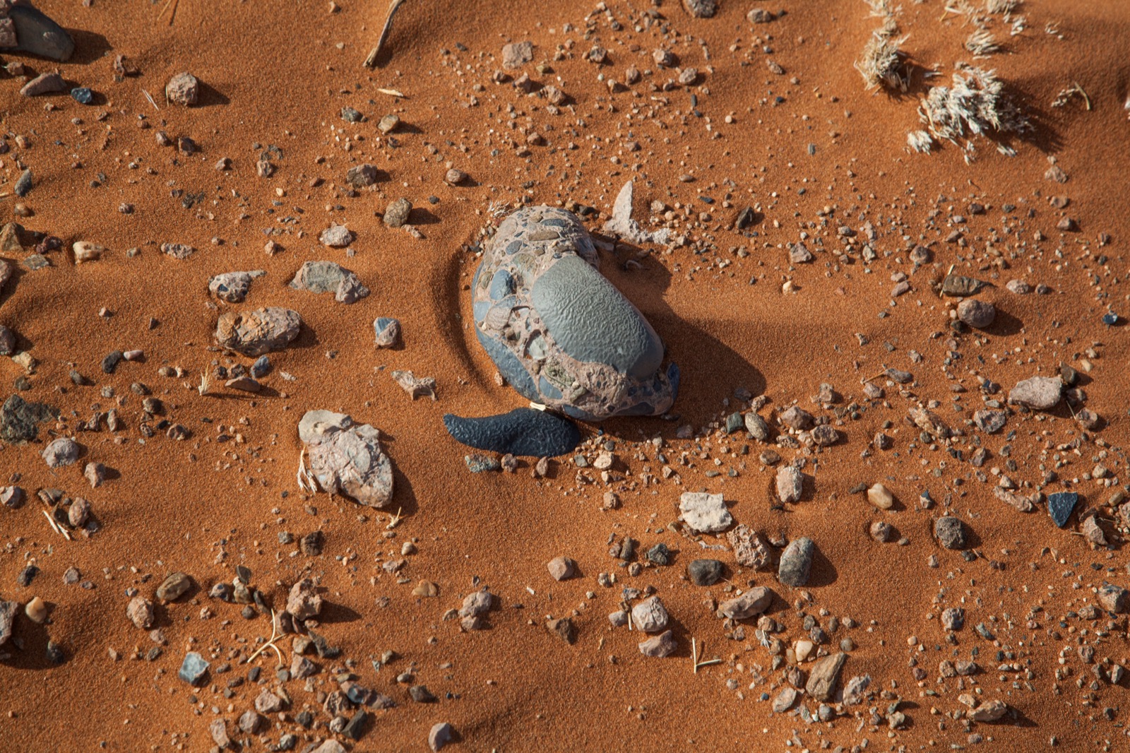
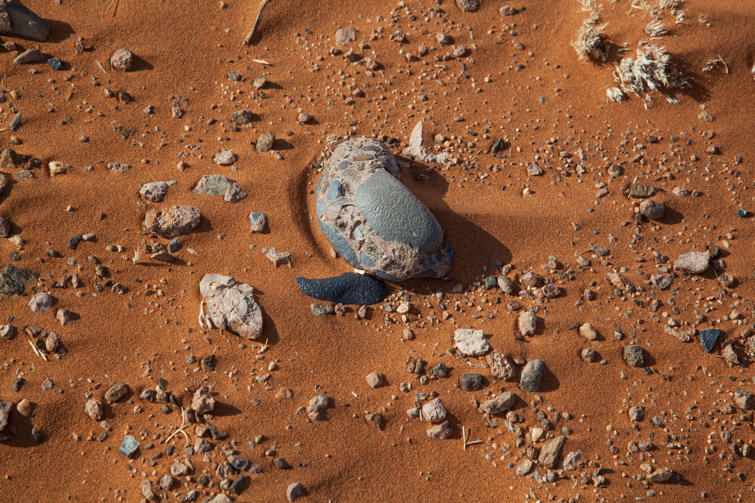
3. detail Red sand, scattered pebbles, and one stone that is not like its neighbours: a smooth, flat, pale gray face, sharply bounded, on a rock that is otherwise rounded and knobbly. The neighbours are rounded. This one has been cut. 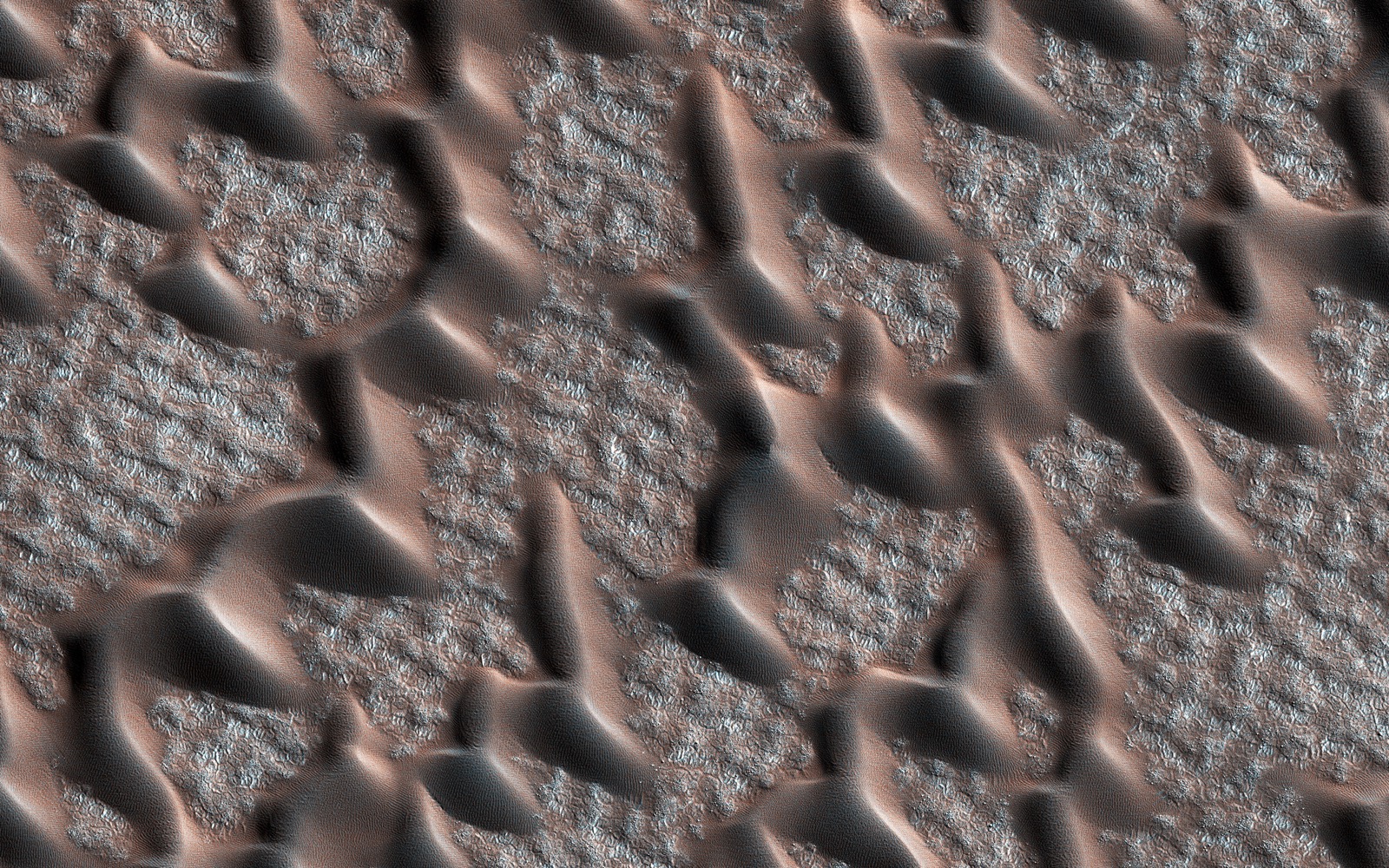
4. comparison The same forms, on another planet. Dark dunes march in rows across pale ground near Mars’s permanent polar cap. The air here is about one percent as dense as the air at sea level on Earth. Nothing about the shapes tells you that. 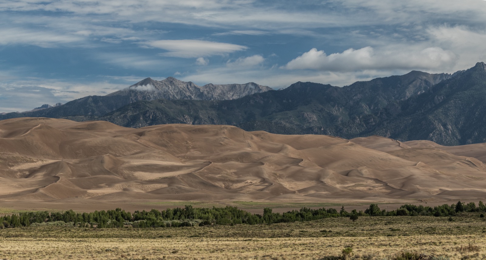
5. human-scale The same process, at the largest scale it reaches on this planet. A field of dunes hundreds of meters high, with a mountain range standing immediately behind it. Ask students why the sand stopped here, of all places — the answer is in the mountains.
01. Setting the stage · 5 min
Project photograph 1 with no title, no caption and no context. Say nothing about it. Ask one question — “Something made this pattern. What?” — and take four or five answers. Do not confirm or correct any of them. Write the guesses on the board. Then ask a second question and leave it open: “There are faint curved lines in the sand beside the grass. What drew them?”
First guess. Look at photograph 1. Something made this pattern. What?
And a second one. There are faint curved lines scratched in the sand beside the clump of grass. What drew them?
Do not erase either of these. We are coming back to them.
02. Engaging with the story · 10 min
Show photographs 2, 3 and 5 — not 4 yet. Give students a job before you start. If Greg’s field account has been recorded, read it aloud while the images are on screen. If it has not, give students a silent minute with each frame instead.
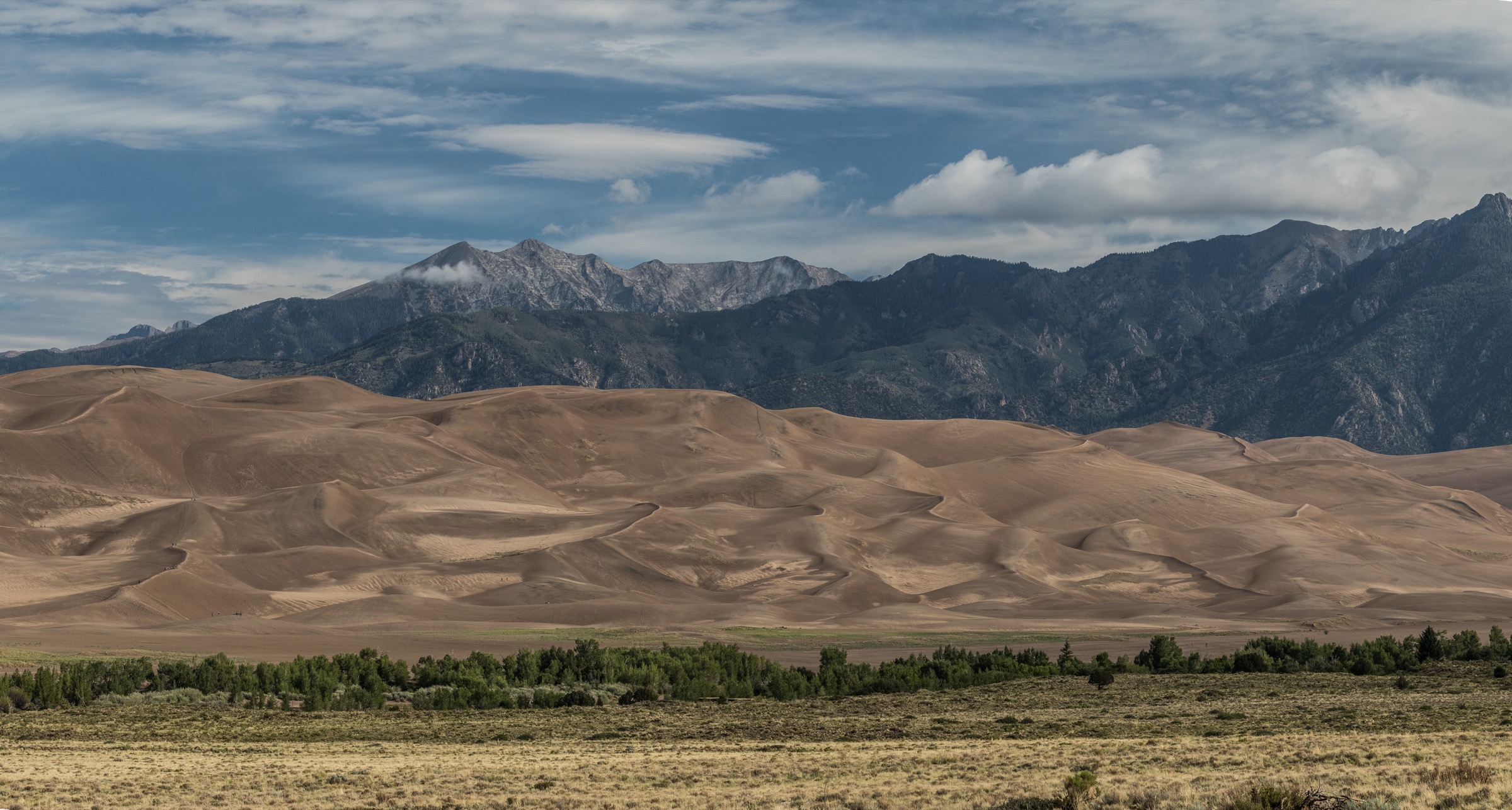
For each one, write down one force that could have shaped it, and one piece of evidence in the photograph that supports your answer.
03. Working the evidence · 15 min
The core of the investigation. Students work in pairs on the handout, using the Observe, Reflect, Question structure the Library of Congress developed for reading primary sources. Put photograph 1 back on screen and leave it there.
Observe (5 minutes). Record only what is visible. No explanations yet.
- What do you notice first?
- How far apart are the ripples? Are they the same everywhere in the frame?
- Which way do the ripple crests run? Are they straight?
- What materials, textures and colors can you see? List everything.
- Look again for a full silent minute. What did you miss?
Reflect (6 minutes). Now generate and test explanations.
- Which direction was the wind blowing, and how do you know?
- The ripples change near the grass clump. What is the grass doing to the wind?
- What drew the curved lines? What would you need to see to be sure?
- Compare photograph 1 with photograph 5. Is a dune just a very large ripple?
- Photograph 2 shows a narrow canyon with smooth, curved walls. Two different forces could have shaped it. Which do you think it was, and what in the photograph makes you think so?
- What is missing from these images?
Question (4 minutes).
- What do you wonder about: who, what, when, where, why, how?
- Standing there with any instrument you wanted, what would you measure first?
04. Delving deeper · 10 min
Now name the mechanism: wind moves material three ways — suspension, saltation and creep — and grain size decides which. Give them the one-centimeter figure and let it land. Then show photograph 4 for the first time and say only, “This one was taken on Mars.” Give it a moment. Then hand out the data.
Read all three tables before you answer anything.
| Mode | What moves | How it moves | How far it goes |
|---|---|---|---|
| Suspension | Particles less than 0.2 millimetres across | Held up by the air and scattered aloft as dust or haze | Indefinitely — hundreds of miles |
| Saltation | Sand-size grains | A series of jumps or skips, lifted no more than one centimeter above the ground, at one-half to one-third the wind speed | Short hops; stays local |
| Surface creep | Grains too heavy to hop | Pushed along by other grains landing on them | Slow — but as much as 25 percent of all grain movement in a desert |
Source: U.S. Geological Survey, Deserts: Geology and Resources.
| Measure | Mars | Earth |
|---|---|---|
| Surface pressure | 6.36 mb | 1014 mb |
| Surface density | About 0.016 kg/m³ | 1.217 kg/m³ |
| Surface gravity | 3.73 m/s² | 9.82 m/s² |
| Main gas in the air | Carbon dioxide, 95.1 percent | Nitrogen, 78.08 percent |
| Are the dunes moving today? | Yes — dunes as thick as 61 meters have been measured moving as whole units | Yes |
Sources: NASA/NSSDC planetary fact sheets; NASA/JPL, 2012.
| Measure | Value |
|---|---|
| Where it comes from | Dry soils — more of it once the crust holding the surface together is broken |
| Where it lands | Downwind, including on mountain snow hundreds of miles away |
| What it does there | Makes the snow darker, so it absorbs more sunlight and melts earlier |
| Measured effect on peak runoff | On average 3 weeks earlier at Lees Ferry, Arizona, under heavier dust |
| Measured effect on the year’s total runoff | Reduced by more than 1.0 billion cubic meters, about 5 percent of the annual average |
| When it started | A fivefold increase in dust was already under way by the late 1800s |
Source: Painter et al., PNAS, 2010.
05. Reflecting and projecting · 15 min
The claim, evidence and reasoning assignment. Two parts. Both appear on the student handout as Part A and Part B.
Part A. Read the evidence. Photograph 4 shows a landform on Mars that looks like landforms on Earth. Based on the photographs alone, what can you conclude about the process that made it — and what can you not conclude about Mars?
Part B. Make the call. A land management agency proposes closing a stretch of dryland to vehicle use. The soil there is a known dust source; the dust settles on mountain snow in another state and moves that river’s peak runoff earlier. Local people use the area for recreation and access, and the benefit falls hundreds of miles away on people who will never know. Should the closure happen?
- Your claim. State your position in one or two sentences.
- Your evidence. At least two specific observations from the photographs, plus one item from Tables 1, 2 or 3. Name the source of each.
- Your reasoning. Explain the scientific and practical principles that connect your evidence to your claim.
Students may submit as a written paragraph, a recorded verbal explanation, an annotated photograph, or a labeled diagram.
06. Take action · 15 min
Ninety-minute path only. Students choose one option.
Choose one.
- Your own wind. What is the prevailing wind direction where you live? Find a surface near your school that it has shaped — a snowdrift, a sand pile, a drift of leaves against a fence. Photograph it and say which way the wind was blowing.
- Mars, this year. Find a pair of HiRISE images of the same Martian dune field taken a Mars year apart. How much moved, and how do you know it is not a difference in lighting?
- Where the dust comes from. Find a dust-source region in the western United States. What changed there, when, and who ended up paying for it?
07. The rebuttal · 15 min
At 90 minutes, add the rebuttal to the claim-evidence-reasoning assignment.
Your rebuttal. Someone reaches the opposite conclusion from the same evidence. State their position as fairly as you can, then explain why the evidence favours yours. If you think the evidence does not settle it, say so and explain what would.
Discussion questions and strong responses
In photograph 1 the ripples are a few centimeters apart. In photograph 5 the ridges are hundreds of meters apart. Are these the same thing at two sizes?
No. A dune is a body of sand large enough to shape the airflow around it and to shed sand down a steep lee slope by avalanching — it has a slipface. A ripple has neither; it is a surface texture made by the impacts of hopping grains. The observable test: in ripples the coarsest grains collect at the crest, and in dunes they do not. Accept any answer that names a mechanism rather than a size.
Photograph 1 shows arcs scratched in the sand beside a clump of grass. What could have drawn them? What would you need to observe to be sure?
The grass is the obvious candidate: blades bending in the wind and dragging their tips through the sand would scribe arcs centered on the clump. Full credit requires the second half. You would need to see it happen, or return and find the arcs changed after a windy day, or check that the arc radius matches the blade length and that the center of curvature is at the clump. Award the highest marks to a student who says the photograph does not establish it — an animal, a person, or the shooter’s own boot could also have made a curved mark.
Photograph 3 shows one stone with a smooth, flat face among rounded pebbles. What could cut a flat face on a stone lying on the ground? What else could explain it?
Wind-driven sand striking one side over a long time can abrade a flat, polished facet — a ventifact. The evidence pointing that way: the stone sits on the surface in a place where sand is clearly moving, and its neighbours are rounded rather than faceted, so whatever did this was selective. But a flat face can also be a fresh break, a natural cleavage or bedding plane, or a water-worn surface, and this stone is a conglomerate whose matrix might simply have weathered away. Strong answers offer a test: is the facet oriented consistently with other faceted stones nearby, is it polished or just flat, and does it show fine pitting?
Photograph 2 shows a narrow canyon with smooth curved walls. Two agents could have shaped it. What evidence would tell them apart?
The two candidates are wind and water. The decisive evidence is height and volume. Saltating sand stays within about a centimeter of the ground, so wind-carried sand cannot sculpt walls from the floor to far above head height. And a great deal of rock has been removed from a narrow slot — water carries that away; wind would have to lift it out. The National Park Service describes canyons of this kind as carved by flash floods. Strong answers notice that the falling particles in the light beam, the one visibly wind-related thing in the frame, are evidence about the air today and not about what cut the rock.
Photograph 4 was taken on Mars, where the air at the surface is about one percent as dense as Earth’s. What does it mean that the dunes there look like dunes here?
It means the process is the same: a directional flow moving granular material produces this family of shapes, and that is physics rather than geography. It does not mean the conditions are the same. Thin air carries far less momentum, so a much stronger wind is needed to start a grain moving — and the dunes are demonstrably active, with NASA measuring whole dunes 61 meters thick migrating as coherent units. The strongest answers state the limit explicitly: a shared landform is good evidence about mechanism and poor evidence about magnitude, frequency or climate.
Open question. Dust blown from disturbed dryland soils darkens mountain snow and moves peak runoff weeks earlier. The dust comes from land people use. What, if anything, should be done?
Answers vary and should. A strong case for acting notes that the measured effect is large — three weeks earlier peak runoff and about five percent of annual flow on a river that 35 to 40 million people draw on — that the cost falls entirely on people who had no part in causing it, and that surface crusts take a very long time to recover once broken. A strong case against notes that the dust increase was largely accomplished by the late 1800s, so restricting use now addresses the margin rather than the bulk of it; that the people bearing the restriction are not the ones who caused the historical change; and that the attribution runs through several steps, each with its own uncertainty. The best answers name what evidence would change their mind, and notice that this is not a scientific disagreement at all — the measurement is not in dispute, the fairness question is.
Answer key
Sample strong responses for each discussion question are held with the question itself. What follows is guidance the answers share.
- Question 1 is scored on MECHANISM, not size. A student who answers “a dune is just a bigger ripple” has read the wrong variable; the slipface is the discriminator.
- Question 2 is only half answered by naming the grass. Full credit requires the observation that would settle it, and the highest marks go to a student who says the photograph does not establish it at all.
- Question 4 is scored on HEIGHT and VOLUME — the two things that separate wind from water here. An answer that simply asserts water is worth less than one that asserts wind and gives the reasoning.
- Question 6 has no key. Score the reasoning and the willingness to name disconfirming evidence, never the position.
The stone in photograph 3 is deliberately not called a ventifact anywhere in this investigation. If a student asks whether it is one, the honest answer is that the photograph does not settle it, and that the useful question is what test would.
The pale material between the Martian dunes is patterned ground, not frost. The catalogue entry for photograph 4 states the dunes are free of the seasonal dry ice at this point in the Martian year, so describing it as ice would be wrong.
Scoring guide
- Claim
- Developing — restates the question or is too vague to evaluate
- Proficient — clear and directly answers the question
- Advanced — precise and appropriately limited about what it does and does not settle
- Evidence
- Developing — one vague reference to the images
- Proficient — two or more specific observations correctly described, plus a data point, with sources named
- Advanced — evidence selected because it is relevant, not just because it was available
- Reasoning
- Developing — restates evidence in different words
- Proficient — names the relevant principle and connects it to the claim
- Advanced — explains why the principle applies here and where it stops applying
- Rebuttal (90-minute path)
- Developing — absent, or dismisses the alternative
- Proficient — states an alternative and answers it with evidence
- Advanced — represents the alternative fairly enough that its holder would accept the summary, then answers it
Common misconceptions
Many students believe wind carves rock directly, the way a sculptor would. The correction: the sand does the cutting, and saltating sand stays within about a centimeter of the ground. Ask why wind-cut stones are found lying on the surface rather than standing up from it.
A second common error. Students treat a dune as a big ripple. Ask what happens to sand that reaches the crest of each, and watch the distinction appear.
A third. “Deserts are made of sand.” Most are not. If a student says it, ask them what the photographs actually show — photograph 3 is mostly gravel.
A fourth, and it fires on photograph 4. Students conclude that because Mars has dunes it must have Earth-like weather. This is the exact inference the lesson exists to break.
Sources
- Eolian processes: suspension, saltation and surface creep — U.S. Geological Survey, Deserts: Geology and Resources. https://pubs.usgs.gov/gip/deserts/eolian/
- Mars and Earth at the surface — NASA NSSDC planetary fact sheets. https://nssdc.gsfc.nasa.gov/planetary/factsheet/marsfact.html
- Measured dune migration on Mars — NASA/JPL, 9 May 2012. https://www.jpl.nasa.gov/news/nasa-spacecraft-detects-changes-in-martian-sand-dunes/
- Response of Colorado river runoff to dust radiative forcing in snow — Painter, Deems, Belnap, Hamlet, Landry and Udall, Proceedings of the National Academy of Sciences, 2010. https://doi.org/10.1073/pnas.0913139107
- National Park Service, “Aeolian Landforms.”
- National Park Service, “Geology,” Great Sand Dunes National Park and Preserve.
- National Park Service, Colorado National Monument, “Breaking and Moving.”
- NASA/JPL-Caltech/Univ. of Arizona, Photojournal PIA22464, “Corduroy Dunes.”
- University of Arizona HiRISE, observation ESP_054161_2540.
- NASA NSSDC, Earth Fact Sheet.
- Library of Congress, “Teacher’s Guide: Analyzing Photographs and Prints.”
- NGSS performance expectations HS-ESS2-1, HS-ESS2-2, HS-ESS3-1.
- The Inquiry Atlas. (2026). The Same Shape on Two Planets: a Visual Field Investigation. Photography by Greg Smith, with imagery from NASA/JPL-Caltech/Univ. of Arizona.